
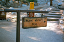
Mount Whitney
Sequoia National Park, California
On August 20, 2002, I set out to fulfill a goal that started as a notion nearly ten years earlier—on my first visit to California, back in 1993, I was awestruck by a peak called Mount Whitney and the desire to reach its summit was overpowering.
After years of hiking and visiting countless areas around the country, and the world, I returned to California in July of 2000—but alas, my dream would remain unrealized.
On that very same trip, I had already hiked the Grand Canyon and Half Dome, leaving just enough time to stop by Lone Pine for a drive up to the Mt Whitney portal—being at the trailhead once again was enough to spark me into action. I made a promise to start training and planning for my goal as soon as I returned home—upon returning, I determined that 2002 would be the year of my summit attempt.
 |
 |
 |
 |
In February 2002, I put in for our permit using the lottery system and was lucky enough to have our first choice granted—August 20, 2002.
Early in 2002, I began to train as hard as I could, living in Ohio, by working out at the YMCA and taking long hikes—the only thing I couldn’t train for was the altitude. That would have to wait until my arrival in California—that acclimatization/training period began on August 17th with a mountain bike outing at Mammoth Mountain and a hike to Rainbow Falls, followed by our first fourteener, White Mountain Peak.
One day before the summit attempt, we picked up our permits at the Lone Pine Ranger Station and then headed to the Whitney Portal Store for their famous burgers and fries—the date was August 19, 2002.
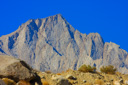
Okay, now for the obligatory facts about the mountain—you probably know that Mt Whitney is the highest peak in the contiguous United States (that means the lower 48 states) at 14,497 feet. It is part of the Eastern Sierra and actually stands in Sequoia National Park, California. Interestingly enough, the lowest point in the United States (Badwater Basin in Death Valley at -279ft) is only about 90 miles from Mt Whitney—quite a contrast don’t you think?
The trail used by most people to access the summit of Whitney is the eleven mile (22 mile roundtrip) appropriately named Main Mt Whitney Trail—the trailhead is at an elevation of 8,365 feet, leaving the hiker with ONLY 6,132 feet to gain.
This trail is obviously very strenuous and most people take a couple of days to hike the entire length. We, on the other hand, decided to join the “death march” and tackle the trail as a dayhike.
Now that the obligatory facts are out of the way, let’s get back to the story. We set our alarm for 1:00am in order to be at the trailhead at around 2:30am—we wanted to give ourselves plenty of time to complete the hike.
We arrived at the trailhead at 2:30am and began hiking at 2:43am under a clear, star-filled sky. The temperature was around 55 degrees and the night was beautiful—our headlamps and the light of the moon perfectly lit the scene. We saw a couple of shooting stars, probably left over from the Perseid meteor shower, and another light show caught our eye as well—this one was more terrestrial in nature and involved the headlamps/flashlights of other hikers out on the trail. We could see the orbs of their lights bobbing along off in the distance, above and below us on the trail, like fireflies in the darkness. In addition to being entertaining, their lights offered a good vantage point for figuring out where the trail was headed—I might add that there is something to be said for hiking in the dark, it sure makes the time go fast and it was so quiet and peaceful.
Especially exciting were the creek crossings—hearing the water long before your headlamp would light the stream can sometimes be unnerving. The first crossing is at about the half-mile mark and then just a little further down the trail you cross the North Fork of Lone Pine Creek and enter the John Muir Wilderness—my watch read 3:12am.
After hiking through a densely wooded area where the plants crowded the trail, (which sparked my imagination with thoughts of wandering bears strolling along only to be disturbed by our presence-yikes!), we arrived at Lone Pine Lake. It was still pitch-black outside and we couldn’t see the lake unfortunately, so it was on to Outpost Camp. Just before arriving at Outpost Camp the trail skirts along Lone Pine Creek with a couple of creek crossings and a beautiful meadow. At Outpost Camp you will locate the first of two solar latrines (see update below) designed for solid waste only. It was now 5:30am and the sun was starting to rise, giving everything a gray-blue cast, but finally allowing us to see our surroundings.
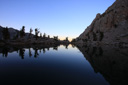
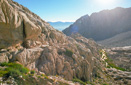
Outpost Camp is a beautiful setting, 3.8 miles into the hike, sitting at an elevation of 10,360 feet. From here the hike becomes extraordinarily scenic, especially when the sunrise starts to light the surrounding peaks. Just past the camp is Mirror Lake, a fantastic glacial lake that is watched over by Thor Peak
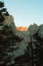
We hiked down to the shore of the lake for a spectacular view of Thor Peak towering over the green water—back on the main trail we started to gain some elevation via a series of switchbacks, until we were high above the lake. It was along this section that the trees began to disappear—we traded the browns and greens of Jeffrey and Lodge-pole pine for the stark whites of the granite that surrounded us in every direction.
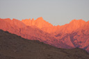
At 6:10am, the sun started to turn the white granite the most subtle shade of pink—so subtle that I at first thought it was just another shade of granite. Eventually, the alpine glow warmed the cliffs to a gorgeous fiery orange—it was absolutely spellbinding!
Trailside Meadow is the next scenic vista along the hike—we arrived here at 6:57am. Several people were gathered along the trail admiring the view, so we did the same—taking in the view and listening to the marmots whistling as they scurried about the meadow.
Just a little further down the trail we came to Consultation Lake and Trail Camp—we arrived here at about 8am and stopped to have something to eat—there is also a solar toilet (see update below) at this point if you need one. Trail Camp is located 6.3 miles into the hike at an elevation of 12,040 feet—many people start to succumb to the altitude at this point.
Just ahead were the infamous 97 switchbacks.
After a brief rest, we packed up our daypacks and braced ourselves for the upcoming climb. It was time to tackle the 97, 98, or 99 (depending on how you count) switchbacks that lead from Trail Camp. In order to give you an idea of how daunting the switchbacks actually are, here are some statistics for you to ponder: from the beginning of the switchbacks to the end of the trail is 2.2 miles and in that distance you gain 1,620 feet, that averages out to 736 feet per mile! Now that I have experienced this trail section for myself, I can tell you that I have unwavering respect for everyone who succeeds at climbing this unrelenting segment of the Whitney Trail.
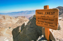
When I finally finished the climb, I stopped again to rest and refuel—I was just around the corner from the much-anticipated “Trail Crest Sign” and as hikers walked past, I could hear their shouts of delight upon seeing the sign—this excitement sure made me eat a little faster!.
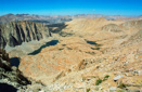
I can’t tell you how exquisite the view is when you round that corner! Sequoia National Park stretches out before you in the valley below, and the jagged peaks of the Hitchcock Range soar above Hitchcock and Guitar Lakes—it is truly breathtaking, no altitude pun intended. At this point, it was noon and we were now at 13,600 feet, 2.5 miles from the summit.
As we hiked along the rocky trail, we paused to look at the smoke that was billowing out of the forest fire in Sequoia—luckily, the wind was kind that day and our views were not affected at all on our entire hike. In fact, the clear blue skies above added even more beauty to the vistas around us. We also began to notice that the trail was starting to lose some elevation—this felt great on the legs, but my mind was imagining how this was going to feel on the return trip—thankAt the 9-mile mark you intersect the John Muir Trail and in my opinion begin the hardest part of the entire hike, the footing along this portion is iffy at best, as the trail becomes quite rocky. I found it hard to concentrate at this point and others agreed that the altitude was making them “slightly goofy” too. It wasn’t anything terribly debilitating, it was just a weird feeling, and although this section was difficult, it was fantastic. The views are second to none, especially the area known as the windows. goodness, it is the only significant uphill portion on the way down.
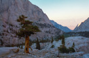
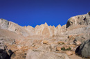
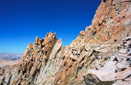
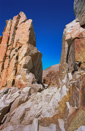
At the 9-mile mark you intersect the John Muir Trail and in my opinion begin the hardest part of the entire hike, the footing along this portion is iffy at best, as the trail becomes quite rocky. I found it hard to concentrate at this point and others agreed that the altitude was making them “slightly goofy” too. It wasn’t anything terribly debilitating, it was just a weird feeling, and although this section was difficult, it was fantastic. The views are second to none, especially the area known as the windows.
The windows are open spaces between huge rock spires where you can see straight down the slope of the mountain—photographs just don’t do them justice, you really have to see them in person to appreciate the vertiginous drops along this part of the trail..
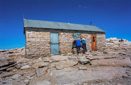
Just a little further down the trail and the summit hut finally comes into view—perched on the horizon, it felt both close and far away at the same time! Nonetheless, the sight of it was inspiring, and I knew I was going to make it at this point, building excitement once again.
As we were making our way towards the summit, several other people were now making their way back down, and many of them seemed to be affected by the altitude—it was subtle, but you could see that they didn’t seem to have control of their movements, especially people with hiking poles. They would kind of flail around almost like they were slightly drunk, it was an interesting thing to watch. Despite the fact that they were tired, everyone who passed us always had words of encouragement and the obligatory “You’re almost there” comment—it was nice to be greeted by such friendly people.
After what seemed like forever, we finally started our final push to the summit—the hut just kept getting closer and closer until, finally, we were there! Standing on the summit of Mt Whitney conjured up such a mixture of emotions—feelings of accomplishment, combined with pain, fatigue, and excitement all flooded to the surface. All I kept thinking was wow, I am now standing on top of the highest point in the lower 48 states—after so many years of dreaming of this moment it was finally happening, such a fantastic feeling!
It was 2:00pm, nearly 12 hours from when I had first set foot on the trail—and I was only halfway through the hike! We left the summit at 2:50pm and immediately noticed that we were starting to get headaches—we were also experiencing some blurry vision, it wasn’t too bad, it just felt like I had tears in my eyes or something.
We also experienced for ourselves what we were witnessing in others as they descended, and that was the feeling of slight intoxication. I want to stress that this was not an overwhelming feeling, it was just very slight, enough to be noticeable. Of course, the further we descended the better we felt
After that slight climb back to Trail Crest we began the agonizing descent down the switchbacks—this about killed my knees. The descent down the switchbacks seemed like it was never going to end, so when it finally did I was ever so thankful. The rest of the hike down was uneventful, and we were really making up some time—we hoped we would be back to the trailhead before dark but that wasn’t to be the case. Darkness soon enveloped the mountain, and when the realization actually set in that we were going to have to put on our headlamps again, I could have just sat down and cried.
At that point, I was cursing the Whitney Trail, and any other trail I had ever heard of for that matter, and I was ready to swear off hiking for the rest of my life lol—funny how that feeling instantly disappears once you finish a hike!
Finally, we arrived back at the Whitney Portal—the time was 8:30pm, exactly 18 hours after we had first set foot on the trail! We never expected that it would take us quite that long to complete the hike, but despite not breaking any speed records, we had all experienced Whitney for ourselves and we were proud of our accomplishment.
Our reward for completing such a grueling endeavor was a huge hamburger and fries from Carl Jr’s—we ate our dinner in our room at the Best Western as we recounted the highlights of our journey.
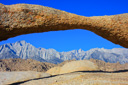
The next morning we drove to Movie Road to get a picture of Whitney framed by the famous arch—it was a great way to bid farewell to our latest triumph.
Mt Whitney will forever represent, for me, a place of unlimited beauty, and high altitude adventure—I am sure I will revisit its grandeur many times in my life, but for now, look out, fourteeners are in my blood—Longs Peak here I come!
Update: Human waste management is a major problem at Mt. Whitney and the Inyo National Forest has instituted a "pack it out" program. At the end of the hiking season in 2006, the Inyo National Forest removed the Outpost Camp solar latrine and will remove the one at Trail Camp sometime in 2007. For more information, visit this link Inyo National Forest-Pack It Out!.
Gallery contains 65 Images
 |
 |
 |
 |
 |
 |
 |
 |
 |
 |
 |
 |