
Half Dome
Yosemite National Park, California
On June 29, 2000, we set out to hike to the top of Half Dome—just three days earlier, we had completed our hike out of The Grand Canyon. Now we were preparing for yet another strenuous dayhike - setting us up for a total of 32.4 miles across two long day hikes.
Our legs were still sore from the canyon, but we didn’t let that stop us—we were determined to see Yosemite's grandeur from the top of its most famous landmark.
The route we were considering to the top of Half Dome was 16.4 miles roundtrip and had an elevation gain of 4800 feet—a long haul under any circumstance, but for muscles already sore and fatigued it was beyond daunting.
After researching our trail options, we decided to take the John Muir Trail (JMT) up, and the Mist Trail down. Content with our choices, we settled into our bunks at Curry Village —setting our alarm for 4:00am, ensuring an early start in order to give our tired legs plenty of daylight in which to complete the hike.
At 4:00 am, we awoke to our alarm and headed for Happy Isles.
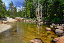
The early morning darkness closed in around us, and our headlamps cast an eerie glow on our surroundings as we walked silently along the path—the morning air was crisp and invigorating, a good sign that the day was going to be pleasant. Soon, we arrived at Happy Isles and began hiking up the trail to the Vernal Falls Bridge. After about a mile, we reached the bridge and stopped to awe at the force of the Merced River. The morning light was just starting to give everything a bluish-gray hue—conveying a sense of serenity and silence, especially since we were the only people on the trail.
Upstream, Vernal Fall cascades 317 feet over the lower step of the Giant Staircase. A little farther down the trail there is a wooden structure that houses a bathroom, a water fountain, and later in the day, tons of people. From this point, the trail starts to climb, gaining some elevation as it passes the junction with the Mist Trail at 0.9 miles—the Mist Trail, another trail that leads to the top of Vernal Fall, is a steep, slippery and wet route that we felt was better left for the return journey. We continued following the JMT, climbing up the switchbacks towards the brink of Vernal Fall—pausing briefly for a view of another waterfall, Upper Yosemite Fall, across the valley in the distance.
After hiking a little further, 594 foot Nevada Fall comes into view, providing a heart-stopping panorama that is typical of the grandeur of Yosemite.
In a few more miles, 3.5 from the trailhead, you will find yourself standing on the bridge that spans the tumultuous waters of the Merced River, watching as it plunges over the edge and down into the valley—an intimidating sight, particularly because of the deafening roar of the rushing water.
As we marveled at the force of Mother Nature, we munched on some baby carrots and rested our legs — renewed, we continued up the trail, passing a rest stop where there is a bathroom on the left side of the trail.
From the rest stop, the trail becomes rather steep for about a mile, but then you get closer to the meadow and it starts to level out—the path from here to the Little Yosemite Valley campground can be quite dusty, but it is a welcome rest to the legs since it is relatively flat. Along this portion of the trail, be sure to take time to walk over to the Merced River, which is less turbulent at this point—the waters are now quiet, dark, and deep. It is a nice divergence from the strenuous hike, to stand on the banks of the river and watch as trout swim in its emerald waters. After enjoying the serenity of the river waters, head north out of the Little Yosemite Valley, passing a shortcut version of the Half Dome Trail—you are now nearly 5 miles from the trailhead.
The trail climbs steeply from this point, briefly following Sunrise Creek, and then it meanders through a beautiful, aromatic forest of pine and cedar—lush and full of life, a deer and her fawn even cross the trail a few yards in front of us. We stop once again to have a quick snack—quick, because if you stop for very long the mosquitoes get a snack too. Just up ahead, a sign marks the Half Dome Trail junction—now 6 miles from the start, it is time to bid adieu to the John Muir Trail if your goal is the summit.
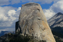
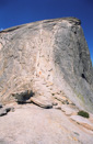
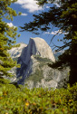
After hiking for what seemed like forever, the trail began to swing westward, finally rewarding us with a view of Half Dome—it looked so far away, but at least we could now see our goal. The trail then swings south, bringing you face to face with the sparsely timbered shoulder of Half Dome. From this point, the trail becomes rockier as you leave the forest and head closer to the granite outcrops. As you climb closer to your goal, you soon come to a sign that warns the hiker of the danger of lightning, advising the hiker to stay away from the summit if storms are looming—after all, the last place you want to be in a thunderstorm is on top of Half Dome, or climbing up the metal cables. Heed the warnings—the summit is not worth your life.
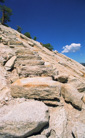
The views along this section of the trail are incredible—worth every aching muscle in your body! Speaking of sore muscles, get ready—you will soon reach the base of the quad-burning, knee jarring, granite steps that lead you up the shoulder to the saddle—the top of the steps become so steep that there is a cable placed along the edge to help you pull yourself up. Just a taste of what is yet to come!
After a long and torturous climb, I finally forced myself up the last step, where I found myself standing at the top—taking in the intimidating view of Half Dome. I was so excited, that I practically sprinted across the saddle to tackle the cables.
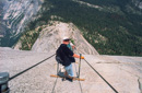
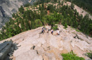
What are the cables you ask? Well let me tell you—the cables are what you shakily use to hoist your tired body up the side of Half Dome. These cables, attached, one on each side, to poles that are approximately four feet tall, form a kind of ladder that is three feet wide—punctuated by 2x4 planks spaced about every five feet or so for footing—hard to explain, just check out the pictures.
They punctuate the last 400 feet of the dome, clinging to the nearly 45-degree pitch—making for a climb reminiscent of a Batman episode. Needless to say, the cables are not an undertaking for those with a fear of heights. In addition to raising your shackles, the cables can also wreak havoc on your hands. At the base of the cables there is a pile of old gloves for anyone to use to protect their hands from the cables—my advice is to bring your own like we did, but regardless, they are there if you need them.
From the base of the mighty monolith, we looked up at the massive dome, visualized the route, put on our gloves, took a deep breath, and started climbing.
The infamous Half Dome cables—what a sight! As we stood at the base of the dome, we could see that the traffic going up was light, so we knew we wouldn’t have to worry about too many on cable collisions or traffic jams. When we reached the cables, we could see that they start out relatively steep, becoming much steeper towards the middle of the ascent. By the time we reached this point, several people were really struggling to pull themselves up—upper body strength is a definite plus.
Another aspect of the climb that creates a challenge is the thin air—the combination of altitude and exertion make this a formidable undertaking! The altitude makes you thankful for each brief break that you get when you stop on one of the 2x4's to let people pass or to let others get ahead. At these rest stops, remember, don't try to stay right behind the person in front of you—let them get to the next plank, then as they leave you proceed to that board, and so on. Then, just when you think your arms are going to give out and your lungs are going to explode, the grade evens out a little, and you can see the top getting closer—then finally you are standing on the top of Half Dome!
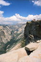
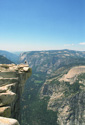
Half Dome, the quintessential symbol of Yosemite, can claim its summit as the goal of just about every hiker who has ever set foot on a trail. Its popularity comes as no surprise, especially when you see the incredible view from the top—the whole valley lies spread out below you in a 360-degree panorama—breathtaking! It is, without doubt, one of the most rewarding hikes that we have ever done. We quickly staked out a little piece of granite where we could sit down and rest and take in the scenery—marmots and squirrels were on the prowl for backpacker lunches, and we watched them sneak up on the unsuspecting hikers and thieve some goodies.
After we rested for a while, and ate some lunch, we decided to break out the cell phone—we had to share our accomplishment with someone and who better to call then mom! We dialed the number and when mom answered, we informed her that we were calling from the top of Half Dome—she loved it!
After a brief rest, we walked all over the flat summit and took photos—one of the best photo opportunities is a pose on top of diving board rock, a slab of granite that protrudes over the side with nothing but 4800 feet of air between you and the ground. Soon, we heard the faint rumble of distant thunder—time to descend!
It was a mad rush to get off the summit before the storm got closer—talk about traffic jams! Oh, and the cables were even more intimidating on the way down! Luckily, we were able to make it down off the dome before the storm hit, and soon we started heading into the shelter of the forest. Before we entered into the tree cover, we turned around and took one last look at the granite monolith—what an adventure!
As we entered the woods it started to rain, and it was beautiful to see all the plants glistening with water droplets - the trail was pretty steep going down, and the rain made it pretty slippery in spots as well, but thankfully, it let up in about 30 minutes.
At this point, the trail was really starting to get the best of me—my knees were giving me trouble, and they hurt so bad that I had to walk backwards down the steeper sections of the trail. I know people probably thought I was crazy, but hey, it stopped the pain.
When we got back to the rest stop where the bathrooms were we switched over to the Mist Trail—providing a shorter route than the John Muir Trail, but steeper—not the best news for my knees!
If we ever do this hike again we will take the Mist Trail up and the John Muir down, much easier on the knees. The Mist Trail has a large section comprised of steep granite steps, and it continues this way for many switchbacks—each step down felt like a knife being jabbed into my knees, the pain was excruciating.
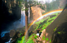
Could anything make up for the pain being inflicted on us?—you had better believe it! When we finally reached Vernal Fall, having already passed Nevada Fall, the sun was shining its rays through the mist that is the trail’s namesake, and you know what you get when those two elements combine—RAINBOWS! Glorious rainbows! They were all along the trail, framing every view as you turned to look back towards the falls. In addition, the mist rolls along the base of the falls until it gently collides with the rock cliffs, bringing with it a refreshing blast for the tired hiker.
After a few more miles of hiking, we finally reached the trailhead and the end of our adventure—we could now mark another hike off our wish list, not only that, but we had accomplished it just 3 days after hiking the Grand Canyon.
It was about 5:00pm when we finished our hike, thirteen hours from when we started—including an hour on the top—and despite our exhaustion, we were thrilled with our achievement. Perhaps one day we will have the opportunity to climb Half Dome again, and if we do, we will not hesitate—it was that great!
Gallery contains 40 Images
 |
 |
 |
 |
 |
 |
 |
 |
 |
 |