
White Mountain Peak
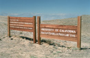
Inyo National Forest, California

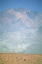
Rising 14,246 feet above the town of Bishop, California looms the summit of White Mountain Peak—the highest peak in the White Mountain Range and the third highest peak in the state of California, after Mount Whitney and Mount Williamson.
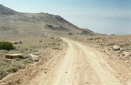
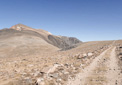
The trail (actually a dirt road) to the top starts at a high elevation, nearly 12,000 feet, so the 7.1-mile ascent is rather gradual, giving White Mountain the infamous title of the “easiest fourteener” to summit. Granted, you only gain a little over 2,500 feet of elevation, but any 14,000 foot peak has the potential to kick your butt if you aren’t prepared, but if you think you are ready for this adventure then head on up to the trailhead via CA168 and you will find it just past the Ancient Bristlecone Pine Forest.
Our attempt to summit White Mountain Peak held a dual purpose—for one, it would be our first fourteener, and two, it would help us acclimatize in preparation for our hike up Mount Whitney. In hopes of fulfilling both goals, we set off into the barren landscape at 11:13am on August 18, 2002.
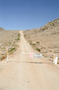
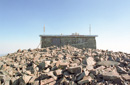
From the trailhead—a small parking area with a locked gate—we began our hike with a smile on our faces and the sun on our shoulders. Armed with backpacks and trekking poles, we were determined to reach the windswept summit. Following the trail/road, we immediately started climbing at a nice gradual incline—after two miles of hiking we came to the first, and really the only, landmark along the trail. The building, once known as the Barcroft Laboratory, is the White Mountain Research Station—a high altitude research station run by the University of California, San Diego. After reaching the station, we stopped for a short lunch break—entertainment provided by the scientists who were busily conducting there duties.
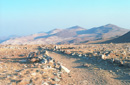
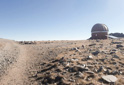
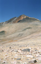
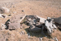
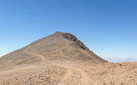
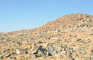
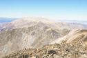
Just past the research station, and a pen where they keep some sheep, the trail crests a pass to a saddle where you will get a good view of White Mountain Peak’s summit—you will also see an observatory off to the side of the trail. Harsh, unsheltered rock formations dot the barren landscape below the summit, providing a stark vista as we made our way through the rolling plains.We picked up the pace a little, as we walked across the saddle—from the saddle the trail descends, allowing for a more relaxed pace.
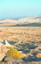
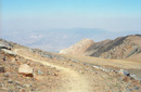
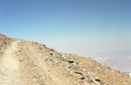
The landscape along the entire 7.5 miles is truly unique—you are above tree line the entire time, so keep this in mind when it comes to preparing for the hike—sunscreen, sunglasses, and a hat are essential.
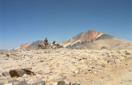
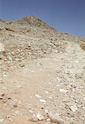
After about a mile of descending, the trail begins to climb again—switchbacking up a scree slope to the summit. As mentioned, the scenery along this hike is quite barren, similar to what the surface of the moon must be like. It is rocky and desolate, but oddly beautiful—the colors of the rocks vary from white, yellow, orange, brown, all the way to red—the different shades blending together on the distant mountainside to form a muted palette.The final climb to the summit is very rocky, mostly following the road, but utilizing some footpaths as well—this last push to the top brings with it a new respect for elevation as our breathing became labored, and we found ourselves stopping to rest quite often. Thankfully, the summit hut is soon in view—having a visual goal helps speed things along. Soon the summit hut seems so close that you could almost reach out and touch it—just keep putting one foot in front of the other and you will soon find yourself standing on the summit of White Mountain Peak!
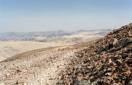
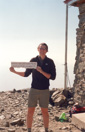
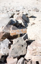
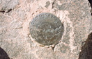
We reached the summit at 4:51pm, five and a half hours after setting out—with congratulations all around, we then basked in the accomplishment of our first 14,000-foot peak. We investigated the summit hut, actually another research station, and signed the register. Then, as we were sitting there enjoying the view we heard a “swish” and looked up to see a gleaming white glider cutting through the thin air above the peak—it was a beautiful sight! A sight that paled in comparison to the panorama that spread out below us from the summit—sweeping views of Death Valley, the Nevada Basin, and the jagged peaks of the Sierra Nevada make for one of the best views in the Sierra. We took in the views for about 30 minutes, before deciding it was time to head back, not at all looking forward to climbing the two sections that we descended on the way to the top.
The highlight of our hike back to the car, was the sight of a herd of ten bighorn sheep and a coyote that gave us a scare when we mistook it for a mountain lion as it disappeared over the ridge. Catching just a glimpse of a large animal climbing over a rocky outcrop, we quickened our pace in hopes of getting a better look—perhaps it was a mountain lion. Once we were able to see the animal, we realized it was not one of the shy cats, but it was the trickster himself, old man coyote. Relieved and disappointed at the same time, we laughed and continued on our way.
We arrived back at the van at 7:31pm - it had taken eight hours to complete the 15-mile trek and we were feeling quite gratified with our successful summit. With one goal complete, we prepared to obtain our second goal—the summit of Mount Whitney. Thanks to the inspirational and sullenly beautiful slopes of White Mountain, we felt confident that we would succeed—we couldn’t have asked for a better peak on which to prepare.
 |
 |
 |
 |
 |
 |
 |
 |
 |
 |
 |
 |
 |
 |
 |
 |
 |
 |
 |
 |
 |
 |
 |
 |