
Longs Peak
Rocky Mountain National Park, Colorado 
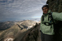
Dragging yourself out of bed at midnight in order to go climb a mountain is an experience all hikers have a love/hate relationship with, and in 2005 on the night of August 11, I was leaning a little more towards the hate feeling. As the clock ticked past midnight, witty remarks from David Letterman provided the background noise as I begrudgingly prepared my backpack for a long day’s journey, for today we would be attempting to summit Longs Peak—the highest peak in Rocky Mountain National Park.
We had traveled to Colorado in order to climb Longs Peak, but also to experience many other aspects of the Centennial State. Unfortunately, the weather had been less than cooperative our entire vacation, making our adventures a little soggy and sometimes rather electrical. Indeed, we had experienced a couple of narrow escapes from lightning—the first being a hair raising incident on Mount Evans. It was on the summit of this drive-up fourteener that we got our first glimpse of the power of lightning, when our hair stood straight up on the top of our heads—this phenomenon occurs when an imminent lightning strike is in the area. Luckily, we were able to run back down the mountain to our car before a strike ever occurred, but it definitely gave us a charge! The second brush with lightning came when a tree was struck just yards from where we were mountain biking at Winter Park. These events, coupled with the fact that Longs is known for its afternoon thunderstorms, was not filling me with confidence, but despite all my misgivings, I was hopeful that the summit was within reach.
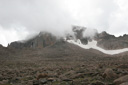
Longs Peak is among Colorado’s Front Range fourteeners where to reach the summit you actually have to use the power of your own two legs—there is no cable car, train, or road that leads to the summit. When you stand on the top of this 14,259 foot mountain, you can be sure that you have earned every degree of the full circle view laid out in front of you!
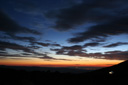
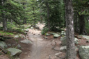
The first steps of our arduous fifteen mile roundtrip journey began at 1:20 am on August 11, 2005. By the light of the early morning moon, we made our way towards the Keyhole—the most popular hiking route to the summit. The Keyhole route corkscrews its way nearly all the way around the mountain, giving the hiker the opportunity to see as much of Longs Peak as possible in a single day—but it would be several hours before we would see much of anything, for now we were hiking in the dark.
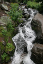
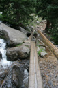
Before leaving, we signed the register, glanced over at the ranger station—where a sign posted the elevation at 9,405 feet, and then set off into the dark forest with only a headlamp to light our way. In the darkness, somewhere along the ascent, the sound of rushing water could clearly be heard as Alpine Brook crashed its way down the mountain. A few trail signs dot the trail, marking off the mileage in the dark—Goblins Forest 1.2 miles, just 6.3 more miles to the summit.
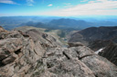
Hiking in the dark amid a light rain, we made good time—content to put one foot in front of the other in an almost trance like state. Then, before we knew it we were at treeline, and at that point, the rain had stopped and the open expanse of starry sky filled the dark void—we were even lucky enough to have timed our hike to coincide with the Perseid Meteor Shower. This astronomical event entertained us every few minutes with a dazzling display of shooting stars—an added bonus to a beautiful hike. Thankfully, it was turning out to be a perfect morning and my confidence level was starting to rise a little bit—it was at that point, that we decided, perhaps, the mountain was going to be kind to us that day.
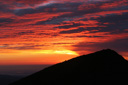
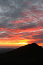
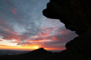
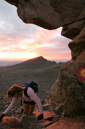
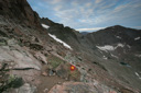
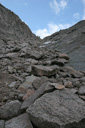
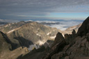
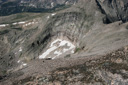
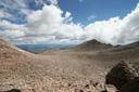
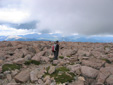
Our spirits renewed, we were able to keep up our steady pace, and we soon reached the Boulder Field—much earlier than anticipated. Unexpectedly enough, it was still dark—we had not expected to cross this rocky terrain by the light of our headlamps, but that is just what we ended up doing. As we hiked closer to the Keyhole the landmark slowly came into view, and a faint blush of color lit the sky. We turned off our headlamps and positioned ourselves to watch the dawn set the sky ablaze over Mount Lady Washington.
 |
 |
 |
 |
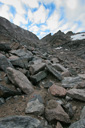
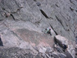
The rocks of the Boulder Field were still wet from the pre-dawn showers, making for treacherous hiking. Due to this fact, a fateful slip could have ended an epic hike—phrases like “teeth knocked out” and “broken nose” come to mind—thank goodness, neither of those scenarios played out.
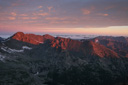
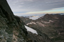
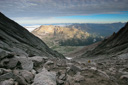
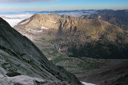
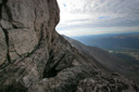
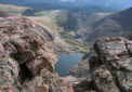
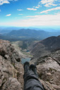
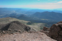
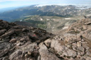
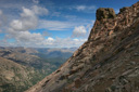
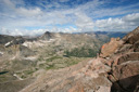
When we finally reached the Keyhole and peered out into the vast expanse of Glacier Gorge, we could hardly believe our eyes! The drop off, combined with the beauty of the scenery, was enough to take your breath away—the mountain tops were painted pink with alpenglow and a carpet of white clouds filled the distant valleys as far as the eye could see! It almost made me forget the harrowing task that lay before us.
 |
 |
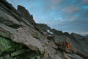
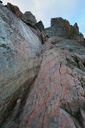
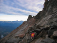
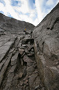
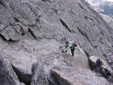
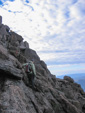
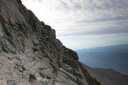
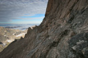
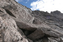
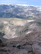
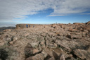
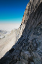
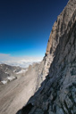
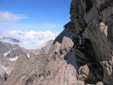
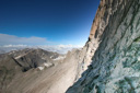
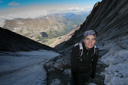
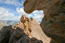
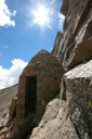
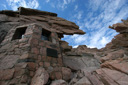
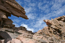
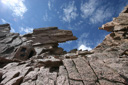
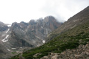
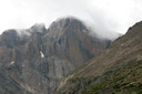
As you may or may not know, beyond the Keyhole, Longs is a more severe mountain—one that transforms the hiker into a rock climber. The climbing is certainly nothing technical, but the Keyhole Route rates as a Class 3 scramble, and it has a great deal of exposure. In fact, once you pass through the Keyhole—a jagged opening in the rocks that serves as a passage to the brutal, cold, dark west face of Longs Peak—you are no longer following a trail proper. The remainder of the route is marked with red and yellow bulls-eyes, or “fried eggs” painted on the rocks—once you pick them out the hard part begins, the part that starts off with the question, “Now how in the Hell do I get up there?”
That was the first question that popped into my mind when I looked over from the Keyhole to the section known as The Ledges—a section where it is necessary to walk along a narrow ridge, holding onto the rock face on the left, while making sure you don't stumble and lose your footing. A fall here, in fact a fall anywhere on the remainder of the route would most likely be fatal. In fact, several of the deaths that have occurred from falls or exposure have taken place along the route between the Keyhole and the summit, rather than on the technical East Face. In many places along this route, I found myself completely clueless about my next move—sometimes it would take a great deal of strategic planning to figure out how to get from point A to point B, and that usually involved a lot of upper body strength. There were several steep sections where the only thing I could do was jump for a handhold, grab on, and then pull myself up until I could reach another foothold—it was like nothing I had ever experienced before!
 |
 |
 |
 |
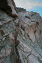
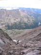
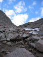
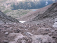
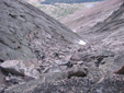
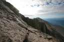
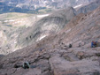
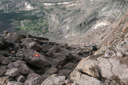
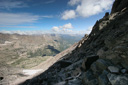
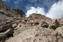
The next obstacle we had to surmount on our way to the summit was The Trough—nearly half of the distance across the west slope is accounted for within this section. The Trough is a geological structure known as a couloir, defined as a deep mountainside gorge or gully, and it is littered with large boulders that take a great deal of energy to climb over as you make your way to the top. In addition to distance, approximately 1,000 feet of elevation gain occurs while climbing this section as well, and most reports estimate the slope to be nearly 30 degrees. Adding to the intense feeling of exertion is the fact that the Trough is at 13,000 feet, making it very difficult to catch your breath. In fact, while standing at the bottom of the Trough attempting to catch my breath, I looked up what appeared to be an endless climb, but it at least appeared safe. A misstep here might only cause a twisted ankle or a scrape rather than a free fall to your death, so we welcomed the respite from fear.
 |
 |
 |
 |
 |
 |
 |
 |
 |
 |
 |
 |
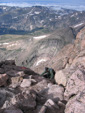
One portion of the Trough, near the top, turned out to be pretty taxing—the trouble began with my decision to climb up a small ridge, which turned out to be more difficult than I had anticipated. Nonetheless, I made it up without any mishaps, but it did make my knees shake a little.My climbing partner had already climbed up a different route and was waiting for me at the top of this segment of the climb, and as it turned out, that route would have been a little less scary.
 |
 |
 |
 |
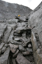
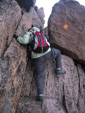
Reunited, we both rested for a few minutes, sipping water as we looked out over the spectacular Rocky Mountain scenery—just a few more feet and we would be at the top of the Trough, faced with one of the most exasperating moves of the entire route. A huge rectangular shaped boulder about six feet tall, topped by other boulders arranged so that there is a small two foot opening for the hiker to squeeze through once up on the boulder, provides the only route option if you want to get to the summit—this type of rock is known as a chockstone. I tried three different times to figure out a way to climb up the boulder, until finally, I gave it another try—I was able to hoist myself up onto my belly, lying on the top of the rectangular boulder inside the small opening. I then slid my knees up under my chest, scraping and bruising my legs on the way up, until I was finally able to stand up.
 |
 |
 |
 |
 |
 |
 |
 |
 |
 |
 |
 |
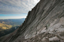
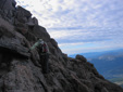
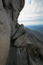
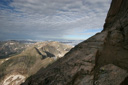
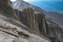
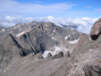
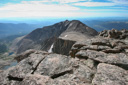
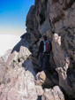
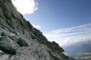
Once over the “boulder barrier,” you are hit with yet another adrenaline-pumping scene—as you look out over the South face of the mountain toward the section called The Narrows, you wonder what the National Park was thinking by letting people come up here—just kidding! Nonetheless, your heart starts pounding as you watch hikers in front of you make their way across the narrow ridge—the Narrows is a ridge that varies anywhere between three and eight feet wide—the upward slope is nearly vertical all the way to the summit, and the downward slope drops thousands of feet to the valley below. We had read many stories about this section of the hike, but nothing prepares you for the firsthand view—after gaping at the view, we set out with great trepidation to cross this nerve-racking segment of the climb. I felt pretty comfortable as long as I had a hand on the side of the mountain for support, and we actually made it through this part of the hike with relative ease. However, I would not want to be on the Narrows when the trail was busy—or worse yet in inclement weather.
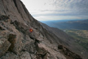
At the end of the Narrows, you head up the Homestretch—a steep granite ramp, perforated with cracks. This is the steepest part of the hike and is rated at about a 35 degree slope—the slope is also relatively smooth, making it that much more slippery to climb up, and that much easier to slip down. The whole way up this beast, all I kept thinking was “How in the Hell do you come back down?” but I would worry about that later, for now the summit was in reach!
 |
 |
 |
 |
 |
 |
 |
 |
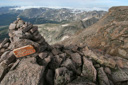
As I got closer to the terminus of the climb, I could see the top of the Homestretch - soon I would be on the summit of Longs Peak, celebrating the victory of a long sought after quest. I paused one last time in the Homestretch and then pulled myself up onto the summit—there on the top of Longs Peak I stared in awe at the expansive views. It had been 7 hours and 18 minutes since I left the ranger station and I was only half way done with my adventure—I would now have to turn around and do it all again in reverse. But for now, I was going to enjoy the satisfaction of a successful summit!
We stayed on the summit for about twenty minutes, enjoying the great views and excellent weather—I would estimate that the temperature was around 65 degrees, with only a slight breeze. We really could not have asked for a better day—we just hoped the fair weather would hold out for our descent. While on the summit, we walked all around checking out the views from each direction until it was time to begin our descent—we then stood at the top of the Homestretch looking down the steep slope trying to visualize the best route down. After a brief debate, we agreed on a path and began our descent—adding to the already difficult route, was the fact (thanks to the rain) that there was a steady stream of water flowing down the Homestretch. This didn’t make for very pleasant conditions, especially when we had to resort to “walking on all fives” (hands, feet, and backside) to get down a particular section—at least the seat of my hiking pants tended to dry off quickly. It took us about forty minutes to make our way down the Homestretch back to the Narrows—the route was steep and sometimes pretty slippery, but we managed to make it down without any problems.
 |
 |
 |
 |
 |
 |
 |
 |
Our return journey across the Narrows was just as intimidating as the first time, except now there was the added burden of two-way traffic. I didn’t like passing other hikers, especially on the more narrow parts of the trail, but once again, we were able to make our way back with little trouble. In fact, I was a little more confident of my safety the second time around, and as such, I was able to take more photos than I did on the way up. One such photo is a nice image of a rock shaped like a car that is known as “The Black Hearse”—knowing this tidbit of information really isn’t a morale booster as you traverse this perilous area.
 |
 |
 |
 |
 |
 |
 |
 |
 |
 |
 |
 |
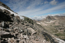
The hike back down the Trough was pretty uneventful as well. Thankfully, the only worry we had while descending was to make sure that we didn’t slide and loose our footing in the loose talus—it is also important to be mindful of dislodging rocks that might tumble down and injure hikers below.
 |
 |
 |
 |
As luck would have it, the weather was still holding up quite nicely, and we were now almost back to the Keyhole—all that was left was to brave the Ledges one last time.
Climbing back across the Ledges requires a bit of elevation gain, not what you want to experience at this point in the hike, but the uphill section is relatively short and painless. One piece of advice, as you make your way back across the Ledges make sure you keep your eye on the red and yellow targets. Many people have gotten off track heading for a notch that they thought was the Keyhole—this notch has been dubbed the “False Keyhole” and several falls have occurred in this area, so be mindful of your route. There is also a sign attached to a rock that points out the way to the true Keyhole—if you see this, you are on the right track.
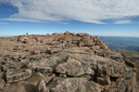
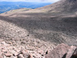
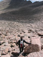
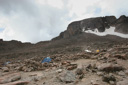
Arriving back at the Keyhole is a good feeling, and as we neared the opening in the rock, we both commented on how small the Boulder Field had been, and how surprised we were that we hiked through it so quickly in the darkness—yeah right! As we came around the last boulder blocking our view and entered the Keyhole, I just about dropped my backpack—I could not believe how vast the Boulder Field actually was, and I demanded to know who had added to it while we were gone!
 |
 |
 |
 |
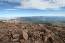
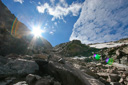
As we made our way down from the Keyhole, across the endless talus of the Boulder Field, we glanced back toward the Agnes Vaille Memorial Shelter and marveled at our adventure so far. The Keyhole was perfectly framed by a beautiful blue sky, which made for wonderful photographs—it took us nearly an hour from that point to cross the Boulder Field. Just as we stepped off the last few boulders, the weather started to take a turn for the worse—we could hear thunder rumbling far in the distance, and the beginnings of a rain shower seemed imminent. We gave thanks that we were off of the most treacherous part of the mountain, and we hoped that we could make it to treeline before things got really nasty.
 |
 |
 |
 |
 |
 |
 |
 |
The rest of the hike back to the car was long, long, long and it was also really LONG. I was beginning to think it was never going to end, and I was once again surprised at just how far we had walked in the dark—there really is something to be said about hiking at night, time just seems to fly by, and when you can’t see just how far away your goal actually is you tend to not get discouraged. For this reason, I highly recommend an alpine start whenever possible—that is coming from someone who really likes to sleep in!
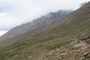
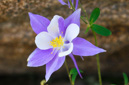
Granite Pass offered some great wildflower viewing and even some wildlife—we caught a few glimpses of pika, ground squirrels, and marmots. The rain was coming down pretty steadily as we made our way to Chasm Junction, and then once there the rain tapered off a bit. Finally, we arrived back at the footbridge that had marked the one-hour chrono of our hike on the ascent. In general terms this should have meant that we were about 30 minutes from the trailhead, which in turn made us excited to see this landmark—but ha, the joke was on us—it took at least another hour from that point!
 |
 |
 |
 |
In fact, it takes almost as long to descend Longs Peak as it takes to climb up—an interesting factoid. Again, we expected the hike down to take half the time of the ascent, so we were shocked when it seemed like the hike went on forever. We just kept walking and walking, until, in the distance, we would see a sign—surely, it would tell us that the ranger station was just around the corner. As we neared the sign there was a slight spring in my step as I prepared for the good news, but when I read the words on the sign, “Longs Peak Ranger Station 0.5 miles” I nearly through a hissy fit—I couldn’t believe it! Someone was surely playing tricks on us, or we took the wrong trail down—there was just no way my mind would accept the fact that the parking lot was that far away! Now, 0.5 miles might not sound like a distance to get that worked up over, but trust me, at the end of a tiring day of mountain climbing it sounds like a marathon distance. When I reached the sign, I muttered a few choice words and then I regained my composure and resigned myself to those last few steps on aching feet.
 |
 |
 |
 |
A short time later we arrived at the Ranger Station with sore backs, fatigued arms and aching feet, but we also had the satisfaction of a great climb! It had taken us 13 hours and 36 minutes to complete the 15 mile roundtrip journey—we had gained 4,854 feet and braved vertiginous drop-offs. Needless to say, we were pleased with our time and with our accomplishment. The only thing left to do was to sign out at the trailhead register and then make a beeline for our car—I couldn’t wait to take off my shoes! After taking care of our duties, and ditching the shoes, the next thing on our minds was food—it was time to feast on pasta and pizza in Estes Park, and then take a well deserved hot bath.
I know words can’t do this mountain justice, but I hope our journal helps anyone out there planning a trip up Longs Peak—just plan ahead, be prepared for all types of weather, carry the right gear and the appropriate amount of food and water, and most importantly—don’t hesitate to turn back if threatening weather is even slightly possible. Remember, the mountain will always be there another day!