
Rim to Rim
Grand Canyon National Park, Arizona

“It must be nice,” or an occasional, “You’re so lucky,” are often the phrases that we hear when we return from another adventure —and yeah, it is nice and we are very lucky, and maybe sometimes to some people our enthusiasm might come across as bragging, but one of the best parts about our travels is getting to tell the story, whether through words or photographs or both. In fact, it has become an obsession—one that leads us far and wide, to new and exciting places. Often, though, it leads us back to an old friend—such was the case, when we set off for Arizona’s Grand Canyon—our sixth visit to this wonder of the world—our third time below the rim, but our first trek from rim to rim, and most likely, not to be our last view of its grandeur.
 |
 |
 |
 |
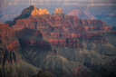 |
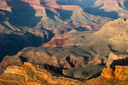
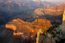
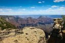
Attempting to describe the beauty of the canyon in words is a difficult task, so I will quote the explorer John Wesley Powell who said it best, “Its colors, though many and complex at any instant, change with the ascending and declining sun; lights and shadows appear and vanish with the passing clouds, and the changing seasons mark their passage in changing colors. You cannot see Grand Canyon in one view.” That last sentence is the one that resonates, the one that brings us back time and time again.
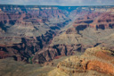
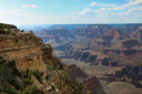
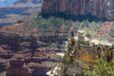
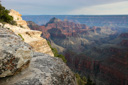
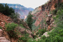
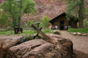
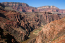
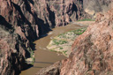
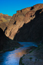
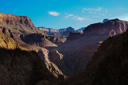
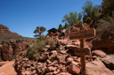
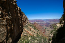
Mather Point, with its classic panoramic view into the heart of the canyon, was our first stop upon arriving at the park—from this vantage point, we could see the cluster of green cottonwood trees at the bottom of the canyon that marks the location of Phantom Ranch, our soon to be home for two nights.
 |
 |
 |
 |
 |
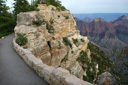
Although all of us, except for Berg, had hiked from the rim to the river and back, it would be the first time any of us had hiked from rim-to-rim. A year previous to our trip we had managed to procure a spot at the Phantom Ranch Dorms for two nights, complete with a steak dinner one night, a stew dinner the next, and breakfast with packed lunches for both days—luxury, compared to our past treks when we camped at the Bright Angel Campground. All of the arrangements had been planned well in advance, and now our adventure was soon to begin, but first, we were going to enjoy a day on the South Rim—touring Grand Canyon Village, hiking the Rim Trail, and touring Hermit’s Road by bus before retiring to the Maswik Lodge.
 |
 |
 |
 |
 |
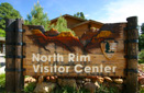
The next morning at 8:00 am, our prearranged transportation to the North Rim via Trans Canyon Shuttle, arrived to take us to our destination. We had privately chartered the shuttle to take us to the North Rim on an early departure time (arriving at 12:30pm) in order to give us a few hours to explore—normally the shuttle leaves the South Rim at 1:30pm and arrives at the North Rim at 6:00 pm—before beginning our hike the next day. The four and a half hour drive went by pretty fast, especially since the drive was so scenic and our driver, Greg, was informative, friendly, and entertaining.
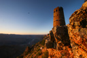
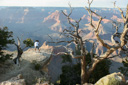
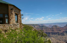
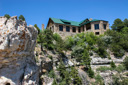
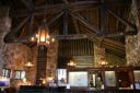
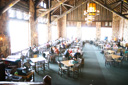
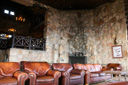
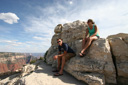
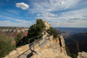
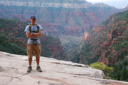
Upon arriving at the North Rim, at around 12:30pm, we sat down for lunch at the magnificent Grand Canyon Lodge Dining Room. After a wonderful lunch, we made our way to the Lodge’s veranda—an open seating area perched on the edge of the canyon overlooking a portion of the Transept Trail, an observation point, and of course, the North Rim. We also spent some time in the Lodge’s viewing room, where you will find soft, leather couches and expansive views afforded by the three huge viewing windows—we decided it was the perfect place to stake out a seat and wait for check-in.
 |
 |
 |
 |
 |
 |
 |
 |
 |
 |
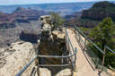
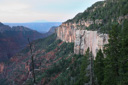
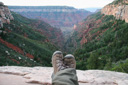
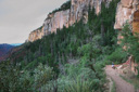
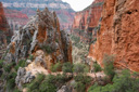
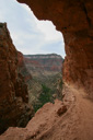
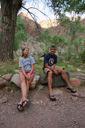
After settling into our cozy cabin, we set out to hike the Bright Angel Point Trail—which, served as a great introduction to the beauty of the North Rim. It was so beautiful, that we even returned for sunset—the Arizona sun at our backs enhancing the immense views of banded reds and browns. It wouldn’t be much longer and we would be boarding the 5:00 am shuttle bound for the North Kaibab Trailhead.
 |
 |
 |
 |
 |
 |
 |
 |
 |
 |
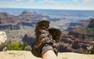
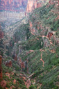
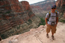
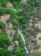
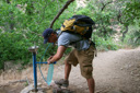
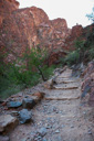
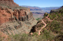
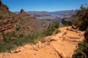
The route we had chosen for our rim-to-rim hike, involved trekking 14.2 miles down the North Kaibab Trail in one day (15.2 miles when you add in the side trails to Roaring Springs and Ribbon Falls), a two-night stay at Phantom Ranch, and a 9.3-mile journey along the Bright Angel Trail back to the South Rim. All in all, it would be a journey of over 24 miles with an elevation change of 10,310 feet in 3 days—not including the day hikes, we planned to do from the ranch. There was no doubt, it would be an adventure to remember, and when we arrived at the trailhead, we (well, maybe not all of us, lol) were eager to get started.
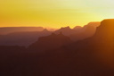
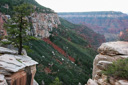
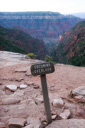
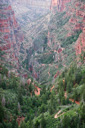
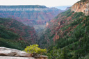
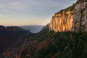
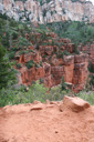
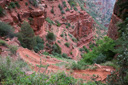
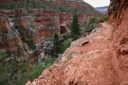
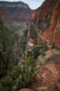
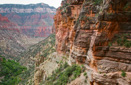
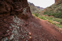
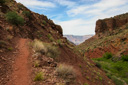
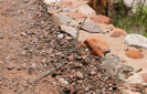
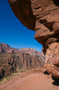
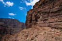
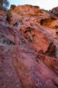
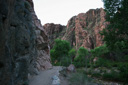
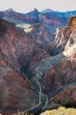
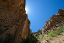
At the North Kaibab Trailhead, you are standing at an elevation of 8,250 feet, approximately 1,000 feet higher than the South Rim, the Colorado River flows through the Inner Gorge 5,850 feet below—more than a vertical mile beneath the rim. As you start down the trail, you will pass through the Kaibab Formation, and the Toroweap Formation, before arriving at the Coconino Overlook perched 0.7 miles along the trail at an elevation of 7,450 feet —the first landmark along your journey. From this point, at the top of the Coconino Sandstone, we enjoyed the view down Roaring Springs Canyon toward its intersection with Bright Angel Canyon. The time was 5:21 am and the morning light cast a muted tone across the canyon walls, and then in an instant the sun appeared to light the sheer buff colored wall of Coconino Sandstone that towered in front of us.
 |
 |
 |
 |
 |
 |
 |
 |
 |
 |
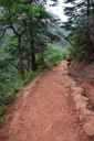
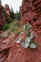
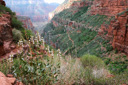
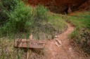
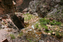
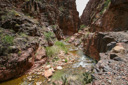
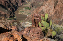
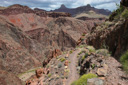
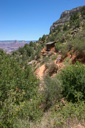
Continuing on down the trail, we made our way towards the Supai Tunnel—passing through more geological history as we delved down through the Coconino Sandstone, the Hermit Shale, and finally, the Supai Group. We watched as the dirt below our boots changed from pale tan to red, marking the transformation in ancient rock layers. The farther we hiked into the canyon, the more spectacular the views became—even Dauster paused to have her picture taken amid, to quote her, “this nonsense.” When we reached the Supai Tunnel, now 1.7 miles below the rim at an elevation of 6,800 feet, we stopped to take advantage of the seasonal drinking water and restrooms—we were now an hour into our hike, feeling great, and destined for the Redwall Bridge.
 |
 |
 |
 |
 |
 |
 |
 |
 |
 |
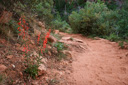
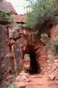
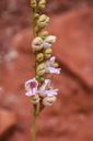
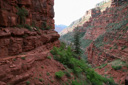
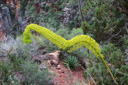
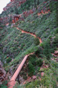
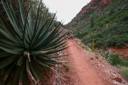
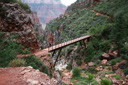
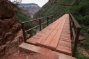
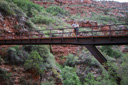
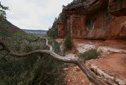
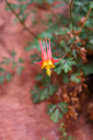
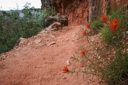
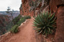
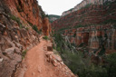
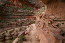
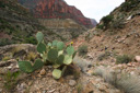
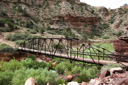
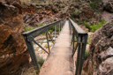
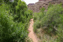
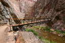
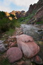
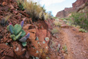
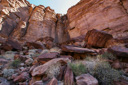
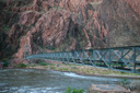
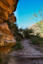
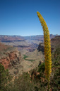
The descent towards the bridge is nothing short of stunning—the trail zigzags its way downward, clinging to the side of sheer cliffs and offering up vistas that are straight out of an art gallery. Utah agave, with its 15-foot bloom stalks, crimson columbine, Indian paintbrush, and clusters of balloon plants grip the edges of the trail and add even more color to the already intense canyon scenery. The bridge itself is a scenic wonder—a man-made feature that seems to blend into the canyon walls. Its appearance marks the distance of 2.6 miles below the rim—just 11.6 miles to go!
 |
 |
 |
 |
 |
 |
 |
 |
 |
 |
 |
 |
 |
 |
 |
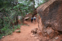
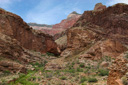
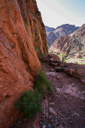
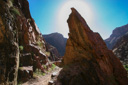
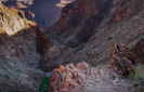
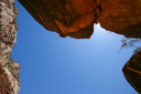
Just beyond the bridge, along a dramatic section of the trail, you will come to The Needle—a massive rock spire off to the left of the trail. We arrived at this point, now 3.5 miles into the hike, at around 7:30 am. Pushing on, we made our way along the seemingly precarious trail, surrounded by imposing cliffs and overhangs on one side, and sheer drop-offs on the other—it was one of the most exhilarating and beautiful sections of the hike.
 |
 |
 |
 |
 |
 |
 |
 |
 |
 |
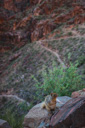
Our next stop was Roaring Springs—a raging torrent of water that can be heard long before it is seen. Located 4.7 miles below the rim at an elevation of 5,200 feet, a portion of the spring, a picnic table and restrooms are reached by hiking 0.25 miles along a side trail—adding half a mile to your total mileage. We arrived at Roaring Springs, the source of water for both the North and South Rim tourist areas, at around 8:30 am. We felt we were making good time, and we rewarded ourselves with a snack break at the picnic table—you will also find a water fountain and restrooms. Joining us for our snack was a persistent squirrel that had us on the alert for a sneak/snack attack—too funny. While we enjoyed our rest at Roaring Springs, we were disappointed that the trail did not lead directly to the waterfall—if there was easy access to the cascade we saw from the North Kaibab, then we missed it. Most likely, you must make your way along the stream towards the spring, but we decided it would be too much effort with what we had in store for us.
 |
 |
 |
 |
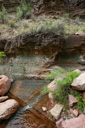 |
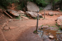
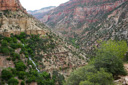
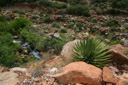
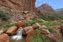
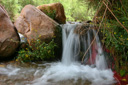
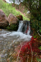
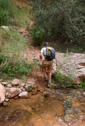
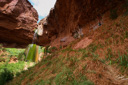
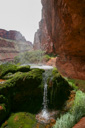
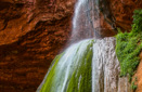
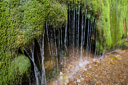
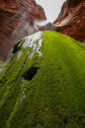
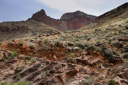
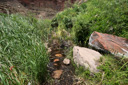
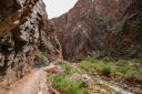
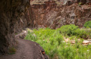
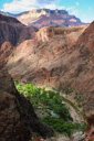
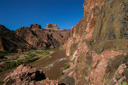
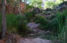
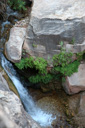
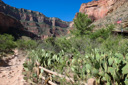
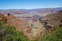
Back on the North Kaibab Trail, we hiked through the gray-green Bright Angel Shale to the brown cliffs of the Tapeats Sandstone strata—yet another visually striking area. These two layers, combined with the Muav Limestone, comprise the Tonto Group—an ancient seabed where the desert ecosystem is now alive and well. Trees are now only visible along shaded slopes or along washes, and cacti dominate the landscape—prickly pear, yucca, agave, and sacred datura are among the prominent plants encountered along this section of trail. Bright Angel Creek is also an integral part of this landscape, and as it flows towards the Colorado River you have numerous opportunities to cool off in its refreshing waters. Just below the Roaring Springs residence, you cross Bright Angel Creek via a footbridge, and eventually reach a fantastic cascade of water off the right side of the trail—this splash of whitewater amid a jumble of red boulders is a cool, lush oasis in the middle of an arid desert.
 |
 |
 |
 |
 |
 |
 |
 |
 |
 |
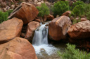
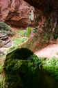
We reached Cottonwood Camp, at approximately 10:30 am, found a picnic table and water faucet near the creek where we rested. While Dauster, and The Berg rested and refueled, I walked down to the edge of Bright Angel Creek where I found another spectacular cascade. The waterfall was the perfect example of a lush riparian environment—yellow monkeyflowers, cottonwood trees, and vibrant magenta algae surrounded the creek. After snapping a few photos and soaking my headband in the cool water, I made my way back to the tables—everyone seemed refreshed and ready to hit the trail again.
 |
 |
 |
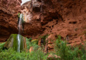
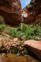
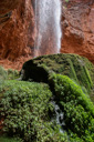
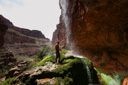
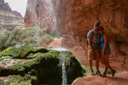
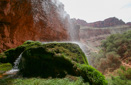
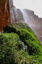
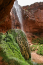
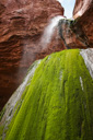
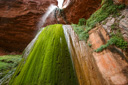
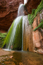
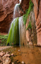
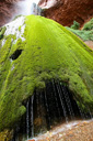
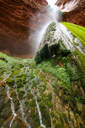
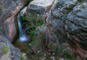
A few miles ahead of us, at mile marker 8.3, we would come to the side trail to one of the most magnificent landmarks along the North Kaibab Trail—Ribbon Falls. To reach the falls, follow the marked path for a 0.25-mile (half-mile roundtrip) excursion to a wonder of the canyon. Ribbon Falls, a veil of water that flows from the top of a cliff onto a travertine mound covered in lush green vegetation, was the highlight of our trip. Hiking down the spur trail from the North Kaibab junction, you will soon cross a footbridge and head into a side canyon where the trail follows Ribbon Creek—the falls is not yet visible as the topography of the canyon hides the cascade well.We made our way upstream, until we rounded a bend and got our first glimpse of Ribbon Falls—what a sight! Words cannot do the scene justice—never would we have imagined such a place existed within the depths of the canyon—it is truly an oasis. Mosses, maidenhair ferns, and monkeyflower thrive in the microclimate created by the waterfall—be sure to protect this environment as you explore, tread lightly. We explored the alcove and the ledge behind the falls, all of which were stunning. Soon, we were basking in the coolness of the waters—it is possible to stand under the falling water while on the ledge behind the falls. We spent nearly an hour at this exquisite masterpiece of nature before setting off for Phantom Ranch—now just a little over 5 miles away.
 |
 |
 |
 |
 |
 |
 |
 |
 |
 |
 |
 |
 |
 |
 |
 |
 |
 |
 |
 |
 |
 |
 |
 |
 |
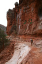
Back at the trail junction, we followed the switchbacks rising steeply over the hill, descending just as steeply down the other side towards the edge of Bright Angel Creek. The trail continues down the broad, spectacular canyon, staying atop a shrub dotted bench above the creek—it was so hot at this point, that I felt like running down the steep slope to the cool waters below. We would later find out, that the temperature, 107°F, was the record for that day in history—no wonder we were hot! Up ahead, the creek dives into an inner gorge known as The Box, but before reaching this narrow cliff-lined canyon, get ready to slosh through the mud. A seemingly out of place marsh, bordered by thickets of willow, saw grass, and horsetails, resonates with the sounds of thousands of cicadas and stands between the hiker and dry tread. There is no getting around this obstacle—you must traverse this wet stretch of land, often times submerging your feet in the quagmire. Take heart though, when you emerge from the stagnant, damp waters of the marsh, you will be delighted to see the clear waters of Bright Angel Creek—beckoning summer hikers to take a dip.
 |
 |
 |
 |
 |
 |
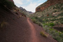
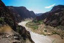
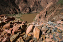
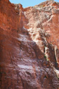
Once again on terra firma, the walls of greenish-gray Bass limestone begin to enclose the canyon as you enter The Box—soon the canyon becomes a narrow, twisting corridor, hemmed in by the dark, convoluted walls of Vishnu Schist. Along the entirety of the hike through The Box, you will be accompanied by the flowing waters of Bright Angel Creek—the narrow cliffs amplifying the sounds of the water. Four bridges en route facilitate passage across the creek, and counting them down is a good way to gauge your remaining time in The Box.
 |
 |
 |
 |
 |
After 3.7 miles and 75 minutes of hiking, the canyon begins to open up—once again South Rim views unfold, appearing much closer and more attainable than before. Much more motivating than the views, was the fact that the Phantom Ranch Cantina, stocked with ice-cold lemonade and iced tea, was now within reach. We were nearing the 3:00 pm mark, and the Cantina closes at 4:00 pm, not to reopen until 8:00 pm, so the pressure was on to keep moving—though, we were still able to take two or three refreshing dips in the creek along the way.
Soon after crossing the fourth and final bridge inside The Box, I stopped to take some photographs and soon found myself separated from my friends—not an issue, until I noticed an unfamiliar snake on the trail in front of me. The snake, racer-like in appearance, moved with its head raised off the ground and was approximately five feet in length, and it paused several times in the middle of the trail to take a look at me before moving on—I was later able to identify it as a non-poisonous striped whipsnake.
 |
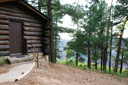
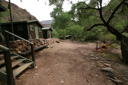
As soon as the snake exited the trail, I was able to catch up with the crew—rejoined with my friends, we made our way to Phantom Ranch together. Cottonwoods and mesquite soon appeared, marking the locale, and then the complex itself came into view—The Berg and Dauster, who had arrived about 20 minutes earlier, were waiting for us at the dorms. The time was 3:14 pm, so we still had over 45 minutes before the Cantina opened, giving us plenty of time to stake claim on a bunk bed and stash our backpacks.
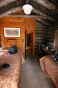
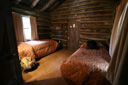
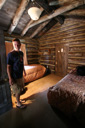
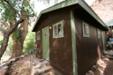
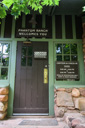
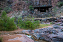
The Phantom Ranch Dorms consist of four cabins, two female and two male dorms, each with ten bunk beds—sleeping quarters for ten people. A towel and linens are provided for guests, and there is a bathroom and shower in each dorm—sheer luxury. In addition, the dorms are evaporatively cooled—a godsend on hot summer nights. After claiming our beds, we made our way to the Cantina, eager to drink as much iced tea and lemonade as possible—a refreshing way to end a day of hiking in the hot desert.
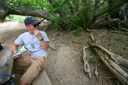
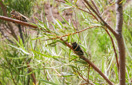
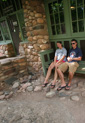
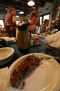
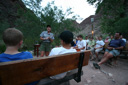
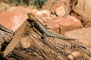
The remainder of the evening was spent resting and walking around the complex, which is an amazing place to see, but the highlights of any visit to the ranch are the meals. We had reserved our dinners over a year in advance, and for our first night, we would be dining on steak dinners at 5:00 pm. As usual, the steak dinner was incredible, complete with vegetables, baked potato, and corn bread. After dinner, we grabbed a shower, hung out at the ranch, and then caught the ranger talk at 8:00 pm—on the way to the talk, we came across a juvenile king snake, identified with the help of the resident ranger. The presentation, given by Ranger Pam Cox, was a Q and A for all to enjoy—covering topics such as flora and fauna, geology, and general facts about the park and the canyon. Ranger Pam, a highly energetic speaker and thoroughly informed naturalist, wrapped up the interpretive talk with a nighttime scorpion hunt—using a blacklight flashlight (scorpions fluoresce under blacklight) —Pam located several specimens for our group to enjoy. The climax of the “hunt” was when one little scorpion snagged a moth from out of the air, whipped his tail over to deliver the lethal sting, and then scurried off into the brush to feast on his prey—too cool!
 |
 |
 |
 |
 |
 |
 |
 |
 |
 |
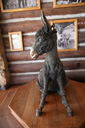
Back at the dorms, we prepared ourselves for bed, and then settled in for the night. I happened to have the top bunk near the door, right under an open window, and the sound of the breeze blowing through the Cottonwood trees was a natural lullaby. At times, the wind was quite strong, and the next morning we awoke to sunny skies and cool temperatures—apparently, a front had come through, bringing with it the most pleasant weather we have ever experienced at the bottom of the Grand Canyon. For the remainder of our time in the canyon, the daytime temperature never exceeded 100°F, a rarity for the Inner Canyon in June, and the nighttime lows hovered around 70°F—we were actually wearing fleece pullovers! We couldn’t have asked for better weather for our Inner Canyon hikes and our ascent out of the canyon—I guess rubbing Brighty’s nose (a good luck charm at the North Rim in the shape of a bronze mule) really payed off!
 |
 |
The wake-up call came at 4:30 am in the form of a knock on the front door, a reminder for those with an early breakfast that food would be served at 5:00 am—for us, breakfast would be at the second seating at 6:30 am. After yet another refreshing shower—dorm life is good—we made our way to breakfast, where we filled up on scrambled eggs, bacon, pancakes, peaches, orange juice, and coffee. The day ahead would be spent leisurely enjoying whatever pastime we preferred—a game of cards, and setting out on a couple of day hikes—namely, the Clear Creek Trail and the River Trail.
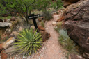
First, we headed for the arduous Clear Creek Trail, which begins about a quarter-mile north of Phantom Ranch. We spent about 4 hours discovering everything that the Clear Creek Trail had to offer, especially the wicked views and dizzying overlooks (click here for a complete description of our Clear Creek hike). When we finished our hike, we made our way back to the Canteen for a beverage—I even enjoyed the diet coke that I carried from the rim.
 |
 |
 |
 |
 |
 |
 |
 |
 |
 |
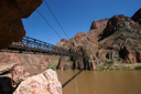
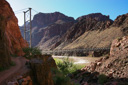
Next on the list of day hikes was the River Trail—a hike that takes you across the Black Bridge, follows the Colorado River downstream for approximately one mile, and finally crosses the Silver Bridge back to the north side of the river and your starting point (complete details here). Our wanderlust fulfilled, we returned to the ranch to wait for our stew dinners to be served at 6:30 pm.
 |
 |
 |
 |
 |
 |
 |
 |
 |
 |
Needless to say, the stew dinners were out of this world—the crew at the Canteen really knows how to take care of their guests! By the way, one of the best parts about meals at the Phantom Ranch, is the fact that they are served family style—giving you an opportunity to converse with fellow travelers. One interesting man we met, named Wim, was from South Africa and our time spent talking to him was time well spent—he was just one of the amazing people we have met on our travels.
Besides eating, you might be wondering what you do for entertainment while at the ranch—put simply, you entertain yourself. Far removed from televisions and cell phones—there are two pay phones though—time spent at Phantom is time to escape our busy lives. Of course, there are the Ranger led programs every night, and we attended Pam’s interpretive talk about bats on our last night in the canyon—another informative and entertaining discussion. After which, we turned in for the night—lights go out early here. Tomorrow, our call for breakfast would come early and then our hike out of the canyon would begin.
We gathered for breakfast, ate our fill, and grabbed our sack lunches on the way out—a demanding journey of 9.3 miles lie ahead of us.
We were on our way to the Silver Bridge and the Bright Angel Trail by 5:30 am, eager to reach the South Rim but a little sad to be leaving the ranch—a bittersweet departure. Having hiked the Bright Angel twice before, we knew that an often grueling hike was in store for us, the one thing on our side was the perfect weather.
 |
 |
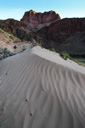
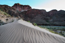
Dauster, and The Berg were setting a fast pace, but I hiked a little slower in order to take pictures—one particularly beautiful scene involved a sand dune, rippled by the wind, just off the side of the River Trail—a shot well worth being left in the dust.
 |
 |
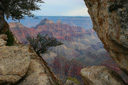
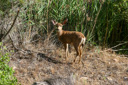
I made my way past familiar landmarks, such as the River Resthouse, Pipe Creek, and the ominous switchbacks known as the Devils Corkscrew. As we neared Indian Garden, the halfway point along the trail, we admired the narrow canyon walls and the waterfalls, pools and chutes of Pipe Creek—there were even several deer accompanying us along our trek. Up ahead, we could see the tell tale cottonwood trees that shade Indian Garden—the clock was nearing the 8:00 am mark, and we could barely believe that we had made it the garden so fast.
 |
 |
 |
 |
 |
 |
 |
 |
 |
 |
 |
 |
 |
 |
 |
We finally left Indian Garden at approximately 9:00 am, ready to meet the challenge of the climb ahead of us. As we were leaving, I glanced over at the thermometer beside the trail—it read 78°F, in contrast, the last time we were at this point it read 113°F!
 |
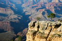
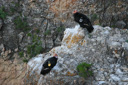
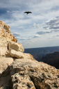
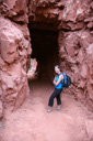
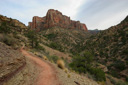
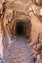
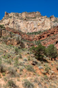
Towering cliffs, massive buttes, and quad burning switchbacks were ours, and metaphorically speaking, ours alone as we climbed the well-trodden path to the South Rim—the canyon vistas remain a gorgeous distraction from the tiresome 4.6 miles to the top. Common ravens and California Condors soar on the thermals above, and spiny desert lizards perch on boulders hoping to stay clear of hikers and mules, as you make your way towards your goal. Slowly but surely, the miles keep clicking by—the Three-Mile Resthouse, the Mile-and-a-Half Resthouse, and then finally the last tunnel all add to the enjoyment of the hike, until finally, you are once again standing on the rim.
 |
 |
 |
 |
 |
 |
 |
 |
 |
 |
 |
 |
 |
 |
 |
The Berg and Dauster had climbed out of the canyon in six hours, and I wasn't far behind at seven and a half hours—reaching the rim at 1:10 pm.
The descent into the Grand Canyon presents a thrilling trip back in time, and the climb out is a challenge that few hikers can pass up, and even though we have made the trek three times, there are still reasons to return. One of the best reasons, is the chance to spend time with friends and family in a place so wondrous that we just can't seem to stay away.