
Mount LeConte
Great Smoky Mountains National Park, Tennessee

Mount LeConte, elevation 6,593 feet, is only the third highest peak in the Great Smoky Mountains but the trails that lead to its summit offer the hiker the quintessential Smokies experience. If you have to choose only one hike in the Smokies this might be the best choice—it highlights everything the park is famous for and it leads to the LeConte Lodge—a few rustic little cabins high in the Great Smoky Mountains. The lodge, reached exclusively by foot, is accessed via any of the five trails that lead to the summit of one of the highest peaks in the park—and although it is not the highest point, LeConte is as majestic as any peak in these rolling mountains, and a highly worthy destination for any hiker.
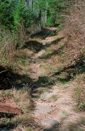
We chose to hike to Mount LeConte via the Boulevard Trail, the longest trail to the summit, with a mileage of 8 miles from the Newfound Gap parking lot. It provides a gradual, steady climb to the summit allowing you to avoid the more strenuous elevation gains involved in hiking trails like Alum Cave, Rainbow Falls, Trillium Gap, or Bullhead—this is not to say that the Boulevard Trail is flat—on the contrary, the trail does have a few rather steep inclines, but nothing that really requires switchbacks. Instead, the climbs are steady, quad burning stretches, which seem to go on forever—making you feel like you are stuck on a perpetual Stairmaster.
To reach The Boulevard Trail you will first take the Appalachian Trail (AT) from Newfound Gap—this portion of the AT climbs 990 feet in 2.7 miles before joining the Boulevard Trail. When you reach the trail junction, you will have climbed from 5,040 feet to 6,030 feet, we were very happy to see that we were already at 6,000 feet—wow, only about 600 more feet of elevation to gain over 5.7 miles, no problem—if only it were true! The Boulevard Trail plays a little trick on hikers past this point—instead of climbing up to the ridgeline; you descend, losing just about all of the elevation that you gained on the AT.
 |
 |
 |
 |
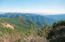
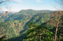
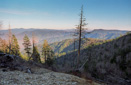
The Appalachian Trail offers great views on its way to The Boulevard, making it hard to keep your eyes on the rocky trail in front of you when just over your right shoulder are magnificent views of the Smoky Mountains and the winding road that cuts through them. Nonetheless, we were making great time and we arrived at the 1.7-mile marker in 45 minutes—we started hiking at 11:25am and our only time limit was to be to the lodge by 6pm for dinner—so far, so good. We continued hiking past Sweat Heifer Creek Trail towards The Boulevard—now only one mile away.
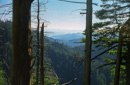
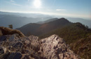
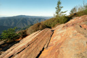
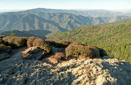
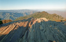
After passing a fantastic open view into North Carolina, taking in Kuwohi, formerly known as Clingmans Dome, the iconic haze covered Smoky Mountains, and the Newfound Gap Road, we soon reached the 2.7-mile marker and the trail junction for the Boulevard—we now had just 5.3 miles to go. We paused here for a short time and talked to a hiker from Tennessee who briefed us on the rest of the trail, and then we parted ways as his party was heading to Charlies Bunion—a spectacular outcrop of bare, jagged cliffs more reminiscent of the young Rockies than the old, worn Appalachians. For a side trip, look for the rugged spur trail called The Jumpoff, which provides a great view of Charlies Bunion. We planned to hike this trail when we reached it in 0.3 miles (according to the trail sign)—we continued to make our way along The Boulevard, reaching the afore mentioned point where the trail begins to descend the ridgeline, but we did not locate The Jumpoff Trail. We were sure we had hiked more than 0.3 miles and decided that we must have missed the trail—we would try to catch it on our return journey.
We had just started to ascend the flanks of Myrtle Point when we decided to stop for lunch along the trail—we chose the sunniest spot we could find as our picnic spot in hopes that it would ward off the chill. The temperature was hovering near the 50 degree F mark, which made for a cold lunch stop despite the sunny locale—we were on our way 30 minutes later.
Soon the trail starts to regain some elevation in order to reach a ridgeline—the climb is steady and gradual but never-ending. Your legs start to feel a little like burning lead and it becomes harder to breathe without panting. You begin to ask yourself why you go on vacation to torture yourself with such pain, but the answer is simple—we go to leave our drab daily routines behind in the search of adventure and when that answer comes to you, the trail seems a little less daunting.
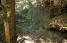
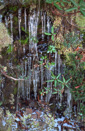
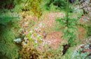
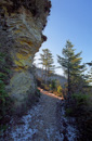
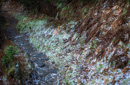
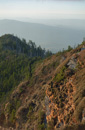
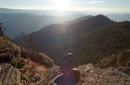
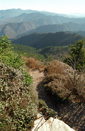
As we hiked across the mountain into its shadowy slope, the air started to feel a few degrees cooler and a dusting of snow covered the moss and lichens that bordered the trail—dagger shaped icicles formed a curtain all along the trail, reminding us that winter was just around the corner. The higher we climbed the more spectacular the views—around every corner a new and beautiful scene appeared, and at one point you could even see the Newfound Gap parking lot way off in the distance.
 |
 |
 |
 |
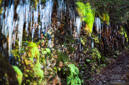
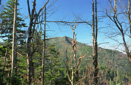
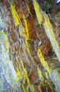
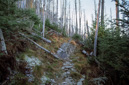
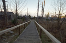
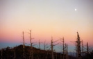
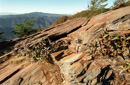
The trail turns from earthy brown to gray slate and then back again as you trek further towards your goal, and every once in awhile you get a glimpse of Mount Leconte and you can feel it getting closer. The last section of The Boulevard Trail is quite amazing, especially at the point where you must cross a massive landslide—a steel cable helps with the footing on the treacherous path through the slide, a necessity when snow or ice covers the trail. Beyond the slide, the trail continues its very rocky and steep approach to the summit—bright neon yellow lichens cling to the cliff sides and ice covered the trail. Just below LeConte’s highest peak, High Top, we passed through a stand of dead fir trees—it seemed that every mature tree was dead, some standing like skeletons in a graveyard, others lie collapsed on the forest floor. As we hiked through the graveyard, the anticipation of reaching the summit grew, and then, just when you feel like you can’t go any further you see it. The rough-hewn little gray cabins of Leconte Lodge sit perched atop the mountain inviting you to stay and relax your tired feet.
 |
 |
 |
 |
 |
 |
 |
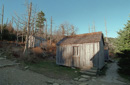 |
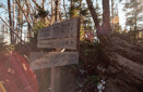
Passing by Myrtle Point and the side path to Cliff Top—a renowned sunset location—we hiked down the gravel-covered staircase to the center of the lodge and then started searching for the office in order to check-in. Soon, we located the office where we met Seth who showed us to cabin 8, our home for the night. Seth informed us that dinner would be at 6ish, so that anyone who wanted to take in the sunset at Cliff Top would have plenty of time. The sun was to set at 5:43pm and it was now 3:45pm, we had hiked 8 miles in 4 hours—not bad.
 |
 |
 |
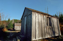 |
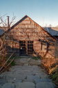
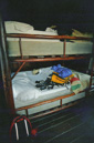
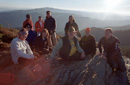
We stashed our backpacks in our cabin and proceeded to investigate the lodge—everyone staying at the lodge was extremely nice and that was no surprise, as they were all hikers, and hikers are some of the nicest people on the planet. The lodge can hold 50 people per night, and is generally sold out months in advance. The cozy little cabins are very rustic indeed—there is no running water (except at the dining hall) or electricity, but they are equipped with a propane heater making it nice and warm. Once the sun sets, oil lamps offer the only illumination, so be sure to bring a flashlight. Speaking of the sun setting, it was now time to head up to Cliff Top in hopes of seeing a dazzling display.
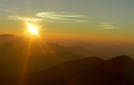
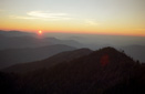
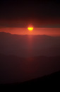
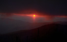
The trail to Cliff Top is just 0.2 miles from the lodge, but it is extremely steep and rocky, so we took our time climbing the path—when we reached the top, there was already a group of hikers sitting on the rocks. These hikers turned out to be some of the nicest people we have ever met while hiking—we exchanged names and trail stories and snapped photos of each other while we waited for the sun to set—what a great way to end the day! Watching the red sun sink beneath the distant peaks of the Smoky Mountains with our new friends, the stress of the world seemed to melt away—indeed our responsibilities were a mile below us and 8 miles away. Another group of hikers who had arrived for the show began singing "God Bless America," which was indeed a poignant moment—with the glow of the sun fading away we all made our way back down to the lodge for dinner.
 |
 |
 |
 |
 |
 |
 |
 |
 |
 |
 |
 |
Dinner was pretty good and consisted of roast beef, mashed potatoes, green beans, corn bread, baked apples, a peach half, and cookies—you could also have hot chocolate, coffee, and water—much better than trail food! Dinner is served family style and we sat eight to a table—again, we were able to meet some great people who shared their experiences and trail stories. We talked into the evening as everyone sipped their hot beverages amid the glow from the oil lamps—soon it was time to turn in and sleep the night away. We headed back to our cabin for some rest, and the cabin was nice and warm. The sleeping accommodations consisted of a double bunk bed, the top bunk being a burning inferno and the bottom bunk being somewhat like sleeping outside in the cold. Neither of us slept very well, thanks to the temperature variations, and the nocturnal activities of a particular mouse. Every time I would fall asleep—on the top bunk—I would be awakened by the sound of 4 tiny little feet scurrying across the boards that made up the ceiling of the cabin. Mind you, these boards were about 6 inches from my nose, but hey, I figure it was his cabin before it was mine, so I just tried to drift away. Finally, morning arrived and the bell was rang to announce that breakfast was ready—Seth also knocked on our door to give us a fifteen-minute heads up.
Breakfast was served just like dinner and consisted of scrambled eggs, ham, grits, pancakes, biscuits and honey, and orange juice—very filling, and great hiking fuel for the upcoming trek. While we ate, everyone exchanged mice stories and I learned the secret to sleeping with mieces—earplugs—I will remember that next time!
After breakfast, we packed up our gear and hit the trail, but before leaving the summit of Mount LeConte, we hiked back up to Cliff Top in search of a benchmark—we were unable to locate one. We then returned to The Boulevard Trail via the Cliff Tops Trail, which skirts along the ridge and then rejoins the Boulevard Trail in 0.3 miles.
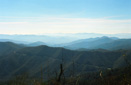
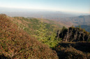
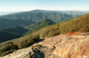
On our way back down the mountain, we took the time to explore the side trail to Myrtle Point, famous for magnificent sunrises and views into the eastern Great Smoky Mountains at any time of day. The spur trail to Myrtle Point is a mere 0.2 miles and well worth the time it takes to reach this spectacular panoramic point. A word of caution, part of the trail follows a knife-edge ridgeline with the ground sloping away on each side of the trail—one wrong step here and you could be in big trouble—so watch your footing!
When we arrived at Myrtle Point, we were impressed by the magnificent vista. We snapped a few photos and trekked on back to The Boulevard Trail—on our way, we heard exclamations of “Hey, its the Natural Born Hikers”—it was our friends Buddy and Tom, from Cliff Top, hiking up to Myrtle Point. We stopped and wished each other a great hike and a safe return as we parted ways.
 |
 |
 |
 |
 |
 |
 |
 |
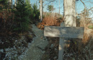
Once back on the Boulevard trail the going was easy—the return to the car is a breeze on this trail—it is mostly down hill and very gradual and easy on the knees, especially with hiking poles. As we hiked along, we kept an eye out for The Jumpoff Trail—the one we missed on the way up—and as we neared the AT junction we found the unsigned spur trail jutting off to the left of the main trail, it is marked only by a rock cairn that is easy to miss. The Jumpoff Trail is not sanctioned by the park (even though they give mileage to it on the junction sign) and it did not appear to be used very much—since we were starting to get tired and the trail looked rugged we decided to bypass once again, maybe we will be back someday—in fact I am sure we will!
Just around the corner was the junction with the Appalachian Trail and from there we were home free—we finished the last 2.7 miles in record time, probably because Backyard Burger was calling our names for lunch! We arrived at the car at 12:45 pm, completing our 8-mile hike in 3 hours and 45 minutes. We unloaded our packs into the trunk and glanced back up at Mount Leconte with a sense of accomplishment—the hike had been wonderful and we had made some great new friends along the way—and that, my friends, is what makes every step worth the effort!