
Rattlesnake Canyon Arches
Black Ridge Canyons Wilderness, Colorado
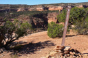
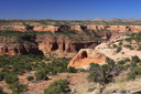
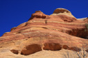
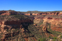
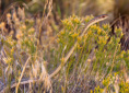
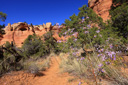
Rattlesnake Canyon, a remote desert wonderland of rock spires, red-walled cliffs, plunging canyons, and dramatic arches, await the hiker that explores this isolated landscape within Colorado’s Black Ridge Canyons Wilderness—but first, you have to reach the trailhead via a high ground clearance four wheel drive access road.
Hidden away on the northwest corner of the Uncompahgre Plateau near the Utah border just west of Grand Junction, Rattlesnake Canyon Arches, the country’s second largest concentration of arches outside of Arches National Park, provides hikers with an intimate look at several arches—six of which are easily discovered.
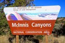
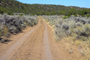
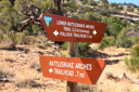
To reach the 6.4-mile roundtrip Lower Rattlesnake Arches Trail, the shortest trail into the canyon apart from rafting down the Colorado River and climbing 1.5 miles up to the arches, you must drive one of the rough, high-clearance required Black Ridge Access Roads (Lower Black Ridge (11 miles) from 8/15 to 2/15, Upper (13 miles) from 4/15 to 8/15, both routes closed from 2/15 to 4/15)—approach is through Colorado National Monument and the Glade Park turnoff leading west to the McInnis Canyons National Conservation Area.
The beginning of the Black Ridge Access Road/McInnis Canyons National Conservation Area is located a quarter-mile from the Glade Park turnoff, then it’s an additional 10.5-miles on the 4WD road to the trailhead—although rough for most of its entirety, only the last 2 miles of the road require serious attention and high clearance—pick your lines carefully.
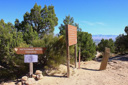
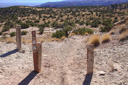
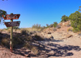
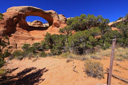
Once at the trailhead, follow the signs to the path leading into the canyon and eventually (0.5-miles from the trailhead) to the trail junction for Lower Rattlesnake Arches and First Arch Overlook—if time allows and you are so inclined, follow the First Arch Overlook Trail a half-mile to a viewpoint overlooking the top of Rainbow Arch, the last arch along the 4.4-mile out and back Lower Rattlesnake Arches Trail.
The view from First Arch Overlook leaves much to be desired, but could be considered worthwhile if time allows—we suggest hiking this spur trail first and then returning to the junction to follow the Lower Rattlesnake Trail where the truly impressive arch views await.
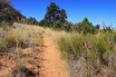
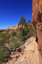
Back at the junction, follow the Lower Rattlesnake Arches Trail further into the belly of the canyon, descending steeply to the base of the escarpment—loose rock and a steep grade make the 0.2-mile downward slope from the top of the plateau the most difficult section of the hike.
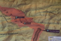
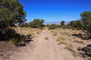
The knee-jarring descent ends at the junction with the Pollock Bench Trail, an alternate route into the canyon that requires a 15-mile roundtrip hike from the Colorado River—from the junction, turn left and hike in a northwesterly direction on a predominantly level path circumnavigating the base of the high desert rock promontory.
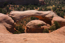
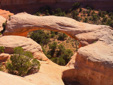
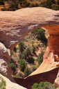
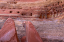
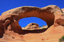
As you notice the route turning to head south-east, gaze upwards to your left to scan the red-rock walls of the cliff for arches—the first major arch, Hole-in-the-Bridge Arch, comes into view after trekking close to a mile. Hole-in-the-Bridge, or simply Bridge Arch, has a 30 foot span and a height of 40 feet, making the 5 by 7 foot opening a dramatic skylight in the bridge-like span of Entrada sandstone—two small alcove arches, one before and one after Bridge Arch, might be overlooked, but once around the bend, the main arches come into view in quick succession.
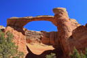
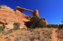
Just ahead the fourth and signature arch comes into view, Akiti Arch—aka Centennial or East Rim Arch, Akiti dominates the landscape, spanning 40 feet across and 120 feet above the desert floor, it has a commanding presence.
The parade of arches continues as you place one foot in front of the other, eventually taking you past Eye Arch, Twin Arches, and Hidden Arch before coming to a dramatic end at Rainbow Arch—Rainbow Arch, aka Cedar or Trail Arch, marks the end of the trail with grandeur.
Rainbow Arch, first encountered from above at the First Arch Overlook, has a span of nearly 80 feet and an opening height of over 40 feet—creating a large portal through which some hikers descend/ascend to shorten the walk. The climb through Rainbow, also called Trail Arch for obvious reasons, is very steep and dangerous—however, if you are brave enough, it would create a significant shortcut. If this route isn’t for you, don’t worry, simply return the way you came for a roundtrip hike of 6.4-miles including the overlook trail.
 |
 |
 |
 |
 |
 |
 |
 |
 |
 |
 |
 |
 |
 |
 |
 |
 |
 |
 |
 |
 |
 |
 |
 |
 |
 |
 |
 |
 |
 |
 |
 |
 |
 |
 |
 |