Lembert Dome Trail
Yosemite National Park, California
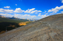
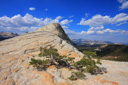
Lembert Dome, a glacially polished granite roche moutonée (a rock formation with a sheer front and sloping back) towering above Tuolumne Meadows, rises to an elevation of 9,450 feet—granting the hiker that gains its summit a spectacular bird’s eye view of Yosemite’s grandeur.
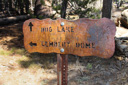
In order to see the summit’s sweeping 360-degree view for yourself, drive Tioga Road to the east end of Tuolumne Meadows—the well-marked Lembert Dome trailhead parking lot is located on the north side of the road. From the parking area, the 2.8 mile roundtrip Lembert Dome/Dog Lake Trail leads north past the restrooms near the west side of the lot—there is also an unmarked footpath at the other end of the parking area that simply leads to a view of the dome and a kick-off point for technical climbers, save it for later. After you have located the trailhead, head north 0.1 mile to a junction—Dog Lake Trail forks left, while Lembert Dome Trail turns right, and immediately begins climbing through lodgepole pine forest towards the dome’s saddle.
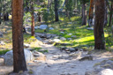
Continue hiking along the sandy trail, passing a few side trails as you make your way towards the dome—the grade becomes more gradual and flattens out at mile 1.2. Enjoy the easy hiking as you skirt past a small pond at the base of the dome—this is a good area to spot wildlife as well, in fact, we encountered a group of mule deer grazing along the side of the trail.
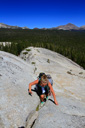
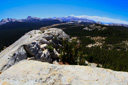
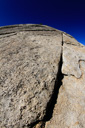
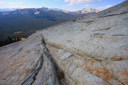
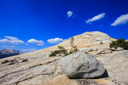
At approximately mile 1.4, you will come to another trail junction—follow the Lembert Dome signs uphill towards the climb to the summit. Once at the base of the bare granite dome, choose your own route along the cracked surface—rock cairns are placed every so often to help you stay on track, but you can go wherever your comfort level allows. From the summit, take in the magnificent views of the meadow far below and the surrounding mountain peaks, including Cathedral Peak, Mount Dana and Mount Gibbs, and Unicorn Peak.
After a sufficient amount of time on the summit, return along the same trail, at least back to the summit trail junction—from this intersection, you can take a left and return the same way for a 2.8-mile roundtrip hike, or take a right for a 3.7-mile loop hike. We chose the slightly longer route and turned right at the junction, following the steep switchbacks downhill to Tioga Road—cross the road at 2.5 miles, and continue 0.1 mile to a parking lot. From the parking lot, locate the sign for the John Muir Trail across yet another road—turn right (west) on the JMT as it parallels Tioga Road, and then eventually leave the trail and cross the road into the Lembert Dome parking area.
 |
 |
 |
 |
|
 |
 |
 |
 |
 |
 |
 |
 |
 |
 |