

Crag Crest National Recreation Trail
Grand Mesa National Forest, Colorado
Crag Crest National Recreation Trail, a knife-edge ridge running east-west through the heart of Colorado’s Grand Mesa National Forest, rises abruptly from high desert landscape and conifer forest to the lofty height of 11,189 feet—perfect for panoramic views of the surrounding mountains, wilderness, and sparkling lakes.
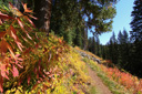
The Crest Portion of the trail, accessed via one of two trailheads (West Trailhead or East Trailhead), travels over the ridge for 6.4 miles and then loops through the forest for another 3.4-miles for a roundtrip loop hike of 10.3 miles including the trailhead access—for a shorter option, we left from the East Trailhead to access the Crest Portion and then return the same way for an out and back hike of 5.1 miles.
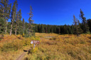
To access the East Trailhead and the route we describe, drive 3.4 miles past the Grand Mesa National Forest Visitor Center along Road 121, following the signs to Crag Crest Campground—the trailhead is located east of the campground entrance and the shores of Eggleston Lake.
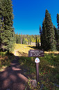
From the parking area, the trail proceeds north for about 0.1 mile to a trail junction with the Lower Loop Trail and the West Trailhead via Crest—follow the West Trailhead straight ahead to access the Crest.
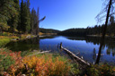
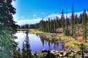
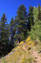
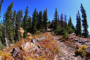
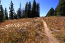
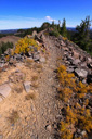
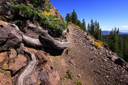
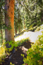
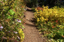
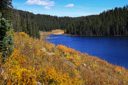
The Crest Portion rises steeply from the East Trailhead to the top of Crag Crest—the route first passes through forests of Engelmann spruce and subalpine fir, passing the west shore of Upper Eggleston Lake(0.75 mile), followed by Bullfinch Reservoir #1(1.25 miles), before climbing in earnest to the crest itself.
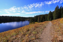
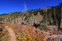
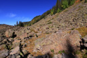
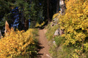
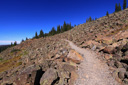
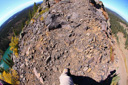
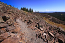
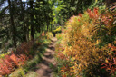
High above Bullfinch Reservoir, along a series of long switchbacks, the trail gains about 900 feet in 2 miles—Butts Lake, nearly a mile long, is now plainly visible as you leave the shady forest for sunshine and boulder fields of jumbled lichen-covered volcanic rubble.
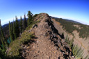
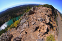
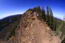
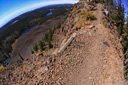
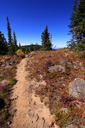
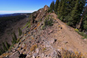
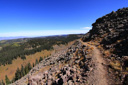
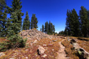
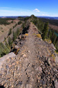
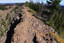
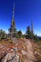
The higher you climb, the more expansive the views become—a final S-curve through an upheaval of dark, porous lava rocks sets the stage for dramatic knife-edge views of the crest and sweeping vistas of the surrounding landscape.
 |
 |
 |
 |
 |
 |
 |
 |
 |
 |
 |
 |
 |
 |
 |
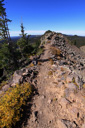 |
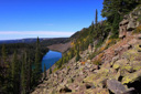
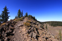
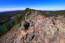
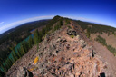
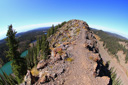
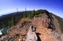
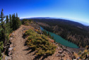
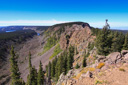
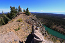
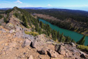
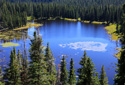
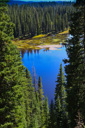
Upon reaching Crag Crest, the trees dwarf and the trail rises to a climactic 360-degree panorama of the Grand Mesa plateau—at times the ridge reduces to a knife-edge barely five feet in width with precipitous drop-offs on both sides, allowing for unparalleled views of the West Elk Wilderness, Uncompahgre Wilderness, Lizard Head Wilderness, and the Raggeds Wilderness, not to mention the chain of lakes on either side of the crest.
A string of elongated lakes along the base of Crag Crest, including Cottonwood Lakes, and Lily Lake to the north and Butts Lake, Rockland Lake, and Forrest Lake to the south, add dramatically to the landscape of the bare Roan and Book Cliffs to the northwest, Grand Mesa’s highest point, 11,234-ft Leon Peak to the east, and the La Sal Mountains to the west.
 |
 |
 |
 |
 |
 |
 |
 |
 |
 |
 |
 |
 |
 |
 |
 |
 |
 |
 |
 |
 |
 |
 |
 |
 |
 |
 |
 |
After following the narrow spine to the highest point above Rockland Lake, we turned around to retrace our steps to the East Trailhead for a 5.1-mile roundtrip hike—Crags Crest offers up views and adventure that even seasoned hikers will find impressive, we highly recommend you take the time to hike part or all of this spectacular trail.
 |
 |
 |
 |
 |
 |
 |
 |