
Chapel Loop
Pictured Rocks National Lakeshore, Michigan

Pictured Rocks, a beautiful area known for towering lakeshore cliffs, forests filled with wildflowers, spectacular rock formations, lakeside beaches, waterfalls, and grand views of Lake Superior, is a nature lovers paradise — finding time to see it all can prove difficult, but not if you hike the 10.4 mile Chapel Loop Trail.
The Chapel Loop Trail, the quintessential hike in Pictured Rocks National Lakeshore, is one of the most sought after treks in the state of Michigan — not surprising, considering it counts among its highlights Chapel Falls, Chapel Rock, Chapel Beach, Grand Portal Point, Indian Head Rock, Lovers Leap, Mosquito Beach, and Mosquito Falls.
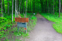
Heading out from the parking lot, we began our much-anticipated adventure — hiking the loop in a counterclockwise direction, we set out for Chapel Falls.
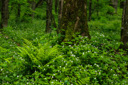
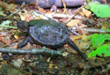
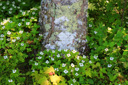
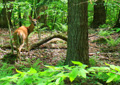
The trail makes its way to the waterfall, 1.3 miles from the trailhead, along an easy, double track path - the wide, old roadbed, is fairly level as it winds its way through a forest as lush as any found in the Pacific Northwest. Along the way to the falls, we encountered a nice variety of flora and fauna — standouts included beautiful Pink Lady's Slippers (an orchid), sandhill cranes, white-tailed deer, a baby snapping turtle, and about three thousand chipmunks ;-)
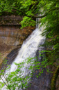
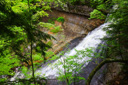
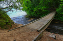
Chapel Falls, a 60 foot plunge along Section Creek, flows gracefully over a cliff on its way to Chapel Lake — your first view of the waterfall is from a platform near the top and then the trail continues, crossing a footbridge over the creek, where you then get another glimpse of the falls through the trees.
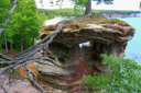
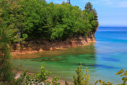
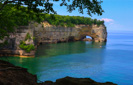
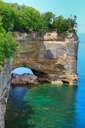
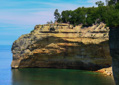
Continue hiking along the forested trail for another 1.8 miles and you will reach the intersection with the Lakeshore Trail (also a section of the NCT) and the second attraction, Chapel Rock — a convoluted offshore sandstone formation ravaged by time and famous for the lone tree perched on its summit, roots stretching across the void to the nearby mainland.
This idyllic scene seemed a fitting spot for a well-earned lunch break, especially for our little hikers age 7 and 10, so we slipped off our backpacks and started to settle in for a picnic when we encountered the one infamous Pictured Rocks resident we had no desire to meet — the dreaded stable fly.
Swarms of these little biting bastards descended upon us as if The Lord of the Flies, Beelzebub himself, had sent them — total buzzkill (pun intended), so packing up as quickly as possible, we ran along the Lakeshore Trail hoping to evade our newly adopted trail mates.
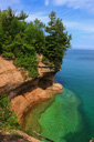
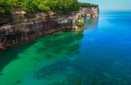
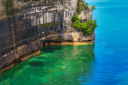
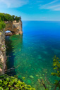
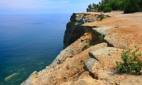
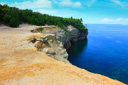
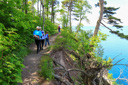
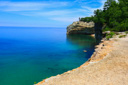
The Lakeshore Trail, 4.4 miles of some of the best scenery in the Upper Peninsula, offers up one spectacular view after another — sweeping views of Lake Superior, the colorful cliffs that make Pictured Rocks famous, rugged beaches, numerous arches and other rock formations make this section of the hike the most breathtaking.
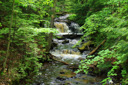
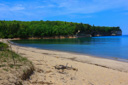
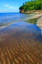
Making our way along the shoreline, using branches as makeshift fly swatters (yes, the flies followed us lol), we dropped down to Chapel Beach and Chapel Beach Falls — a lovely cascade found along the beach where Chapel Creek empties into Lake Superior.
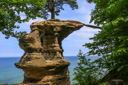
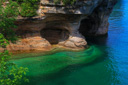
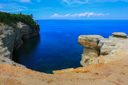
Leaving the beach, we climbed up above the clear waters of Lake Superior to the vast expanse of Grand Portal Point — this flat, sandy clifftop formation (mile marker 4.9) offers spectacular views reminiscent of California's Big Sur. Watch for landmarks such as the collapsed Grand Portal Arch, Indian Head Rock, Battleship Row, and Lovers Leap.
Past Grand Portal Point, the trail skirts the edge of the cliffs for another 3 miles before turning inland — dropping down one last time to the fantastic formations of Mosquito Beach.
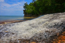
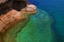
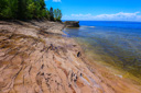
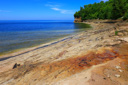
Mosquito Beach, a wilderness beach, is comprised of colorful sandstone shelves and sea stacks set against the clear, emerald waters of Lake Superior — truly a magnificent landscape.
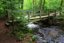
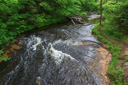
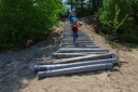
Back on the Lakeshore Trail, at mile 7.8, watch for a path leading away from the cliffs (campsites in the area can make this confusing) and follow it to a footbridge spanning Mosquito Creek.
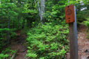
The next 1.9 miles of trail meanders through the forest back towards the parking area — a spur trail leads to the small cascade known as Mosquito Falls, skip it if you are tired. If you bypass this last waterfall you will have hiked a 9.7-mile loop of grand scenery, add the falls and your total mileage jumps to 10.4 — not a bad days trek either way!
 |
 |
 |
 |
 |
 |
 |
 |
 |
 |
 |
 |
 |
 |
 |
 |
 |
 |
 |
 |
 |
 |
 |
 |
 |
 |
 |
 |
 |
 |
 |
 |
 |
 |
 |
 |
 |
 |
 |
 |
 |
 |
 |
 |
 |
 |
 |
 |
 |
 |