
Worthington Glacier
Worthington Glacier State Recreation Area, AK

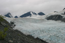
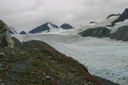
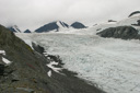
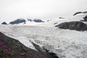
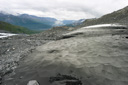
It was a typical Alaskan summer day— the sky was a light shade of gray and its pallor threatened rain at any moment —when we were driving along the Richardson Highway on our way to the Worthington Glacier. For the time being, the raindrops were remaining housed in the clouds—good news for our upcoming adventure. As we rounded a corner on the highway, our eyes were instantly pulled from the sky to focus on the massive glacier that lie ahead—Worthington Glacier dominates the landscape and lures the adventurous off the road and onto its trails. Worthington is yet another of Alaska’s definitive drive-up glaciers, and it has the distinction of being a National Natural Landmark—a landmark that falls four miles from its source to the terminus at the lake below.
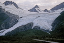 |
With anticipation, we pulled into the parking lot at the Worthington Glacier State Recreation Site—we had consulted our guidebooks and knew that it was possible for the more adventurous to climb along the ridge beside the glacier. Therefore, it was decided that a pass along the glacier’s lower moraine just would not do for us—a line from one of our favorite movies, What’s Eating Gilbert Grape, summed up our feelings exactly—“I wanna go up there Gilbert!”
To get a better look at the glacier, as mentioned above, you have two main choices. First and easiest is to hike along the paved interpretive trail, which leads to a viewing platform with spectacular views of the glacier’s terminal moraine. Second, for a more adventurous undertaking climb the Ridge Trail—making its way steeply over scree, the trail climbs steadily for one-mile along the glacier’s lateral moraine.
 |
 |
 |
 |
 |
 |
 |
 |
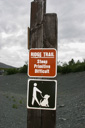
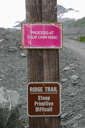
Locating the trailhead for the Ridge Trail was not difficult—a conspicuous sign on the west side of the parking lot reads “Steep, Primitive, Difficult”—just what we were looking for!
 |
 |
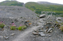
In our excitement to get our hike underway, we chose a more difficult route up the ridge—at the trail sign, we followed a well worn path away from a heavily vegetated portion of trail, which is precisely the opposite of what we should have done. Our decision led us to a steep scramble up a scree slope to reach the top of the ridge, where if we had taken the correct route through the bushes it would have been a lot easier—the route is remarkably obvious once you are up above the parking lot on the ridge, but it is an easy mistake to make from ground level. We talked to several other hikers who made the same mistake—so if you plan to hike this glacier heed our advice and follow the trail through the scrub.
 |
 |
 |
 |
 |
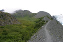 |
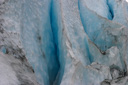
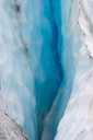
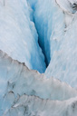
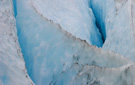
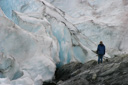
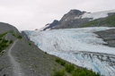
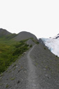
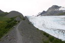
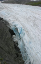
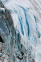
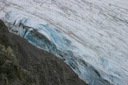
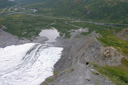
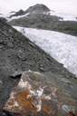
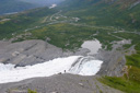
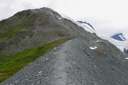
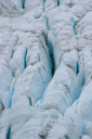
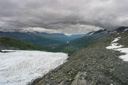
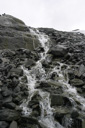
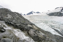
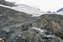
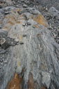
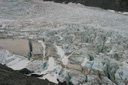
Once we managed to pull ourselves up the steep, loose, scree slope and onto the Worthington Ridge, the views really began to open up—you could see the whole valley spread out below the glacier, above was the view of our long climb up the ridge that paralleled the icy seracs and deep crevasses of the glacier. The hike is only a mile one way but it requires a strenuous 1,200-foot gain in elevation to reach the top—the climb is a real lung buster and it is not for those with a fear of heights or anyone uncomfortable with exposure. The ridge that you hike on is best described as a knife-edge, where the trail is often only a foot wide with steep drops of hundreds of feet on either side—often the footing is poor, and a fall could very well be deadly, so keep your wits about you and respect the potential danger.
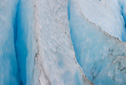
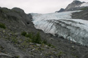
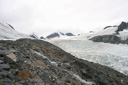
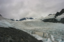
Standing on the ridge above the glacier affords spectacular views of the convoluted ice formations, and the high vantage point is a great place to survey the contrast between the snow white and deep blue colors of the glacier—like many other trails that gain elevation over a short distance, the views just keep getting better the higher you climb along the Worthington Ridge.
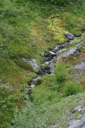
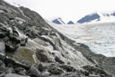
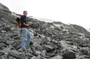
The first section along the knife-edge is navigated with relative ease, but then you enter into some vegetation where the views are obscured, only to emerge from the bushes onto an area of trail that skirts precariously along a huge drop-off—even more intimidating is the fact that the trail is crumbling away at this point, understandably not many hikers are using this path anymore and a new footpath is being worn a little farther out from the edge. Just past this section, you begin to climb another knife-edge ridge—this one even steeper than the previous ridge. At this point, the trail is very narrow and exposed, but soon enough you hike into the shadow of the mountains where the trail broadens—now the route requires some boulder hopping, mixed in with an occasional crossing of a meltwater stream.
 |
 |
 |
 |
 |
 |
 |
 |
 |
 |
 |
 |
 |
 |
 |
 |
 |
 |
 |
 |
 |
 |
 |
 |
 |
 |
 |
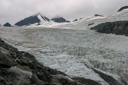 |
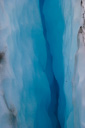
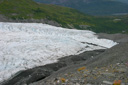
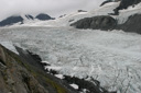
All along the Ridge Trail, the views are incredible—stretched out before you is the huge expanse of Worthington Glacier, its crevasses crossing its snowy surface like blue veins. In addition, you can see where the glacier has eaten away at the mountain’s sides—breaking off huge chunks of rock under its weight and carrying them down toward the glacier’s terminal moraine.
When you reach the top, at an elevation of 3,400 feet, you will quickly realize that you have reached the end of the road—now there is no more trail to follow, only a field of ice spreads out as far as the eye can see. Look around, take in the scenery, and bask in the accomplishment of a successful climb. When you have fully enjoyed the moment, turn around and descend the same way you came.
 |
 |
 |
 |
 |
 |
 |
 |
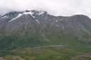
The return hike is just as scenic as the ascent, especially since you get expansive views of not only the glacier but of the valley below as well—a glimpse of the Richardson Highway cutting through the tundra is the only reminder of civilization in this wild landscape. Keep in mind that the descent is very steep in sections—be careful to watch your speed—as mentioned before this is no place to slip and fall.
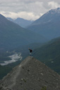
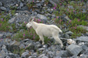
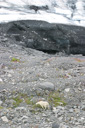
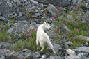
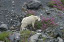
As we hiked back towards the parking lot, we stopped to pose for a photo on the ridge—while sitting above the glacier, we caught a glimpse of some movement down on the moraine. Far below the ridge, grazing amid the fireweed, was a snowy white mountain goat—it was the perfect ending to a spectacular hike filled with highlights.
 |
 |
 |
 |