Mount Marcy—Highpoint of New York
Via the Van Hoevenberg Trail
High Peaks Wilderness Area, New York

Sunshine, heat, humidity, black flies, mud, rocks, clouds, rain, lightning, and blustery winds—encountered all in one day—welcome to New York’s state highpoint, 5,344 ft Mount Marcy. A remote, but popular peak, Marcy delivers an adventure that often allows you to test every piece of gear that you own—bring your quick-dry zip-offs, hot weather clothing and fleece alike, sun visors and rain jackets, and be prepared to use them all. Perhaps one of the reasons that the weather is likely to change during your hike, is the fact that the climb to the highpoint of the Adirondacks is an all day pursuit (just enough time for a weather change in the Daks)—the shortest route to the top, the Van Hoevenberg Trail, requires a roundtrip trek of 14.8 miles and a time allowance of 8 to 10 hours for the average hiker. If you are day hiking the summit, expect to spend a grueling day on the trail—even the Van Hoevenberg, the “easiest” trail, gains 3600 feet of elevation along an often steep, wet, and rocky terrain.
Well, we certainly have painted a lovely picture of Mount Marcy, but despite the often uncomfortable conditions, the views from the top and the incredible beauty of the trailside environment more than make up for the trials and tribulations of the actual climb—so lets make our way to the summit and to some of the best views in eastern North America.
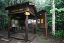
The Van Hoevenberg Trailhead, located at the opposite end of the parking lot from the High Peaks Visitor Information Center (Adirondak Loj area—parking fee $9.00 as of 2007), marked the beginning of our hike—we noted the time and signed the register at 6:48 am. Passing through a stand of pines, we crossed the winding boardwalk over Heart Lake outlet and eventually, entered the High Peaks Wilderness at 0.5 miles—the refreshing scent of pine filled the air, and the sun was slowly lighting up the forest as we made our way towards Marcy Dam—located 2.3 miles into the hike.
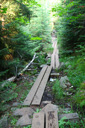
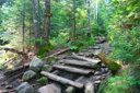
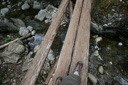
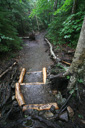
The wide, well-maintained trail adds to the enjoyment of the hike—trail crews have worked tirelessly to improve the conditions of the path, building reinforced steps, foot planks, corduroy, and stepping stones where needed. No need to worry about getting off track either, the trail is well marked with blue-metal disks nailed to trees and trail junctions are well signed—kudos to the trail crew.
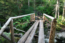
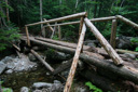
En route to Marcy Dam, we admired the flora and fauna of the Adirondacks, taking note of the impressive birch, maple, and the variety of toads encountered along the trail as we climbed along the ridge above Marcy Brook. An hour into our hike, we crossed the scenic wooden Marcy Dam, taking in the spectacular cross-pond views of Mount Colden, Avalanche, Wright Peak, and Algonquin. Just after crossing the Marcy Dam, we paused to perform our second registration task and then began climbing towards the Phelps Brook stream crossing at approximately 2.5 miles. Along this gradual climb, we were surprised to see a sign for a toilet, just off the left side of the trail—take the side path to the outhouse sans door and “enjoy” this privy with a view.
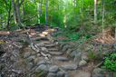
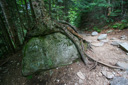
Back on the rocky terrain, we soon reached the High-water Bridge that spans Phelps Brook—during low water, you may also choose to cross 500 feet upstream via the boulder-strewn streambed itself—either way, you end up on the opposite bank where your climb continues. In another mile, approximately 3.5 miles from the trailhead, you will once again cross Phelps Brook. On your way, look for the signed junction for Phelps Mountain—when you arrive, look for the large boulder encased by the roots of a tree—an interesting conundrum. When you reach the second crossing of Phelps Brook, you just might be ready for a dip in the stream—it was nearing the 9:00 am mark when we arrived and the summer heat and humidity were already starting to build. We stopped at the bridge and snacked on trail food before tackling the next section—a steeper climb and larger boulders lie ahead.
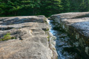
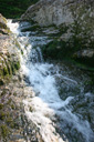
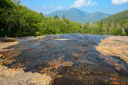
Climbing the large boulders in the oppressive heat proved to be the most difficult portion of the hike for us, but we stopped and rested when needed and soon found ourselves crossing Marcy Brook again (4.2 miles) upstream from Indian Falls. Upon crossing, we followed the signs (an immediate right) for the spur trail to the falls, which leads to a broad open rocky outcrop at the head of Indian Falls—from this vantage point, you get astounding views of Algonquin, the MacIntyre Range, and the waters of Indian Falls spilling through a fissure in the cliff. As is often the case with such panoramic vistas, most of us tend to overlook the small details in the landscape—don’t make that mistake here, as you make your way back towards the Van Hoevenberg Trail, be sure to study the macro environment—lichens, bunchberry, devil’s paintbrush, foxglove, toads and tadpoles round out the scenery.
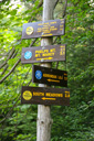
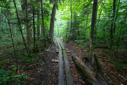
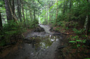
After returning to the trail proper, resume your climb towards the summit—shortly, you will reach the signed Lake Arnold trail junction—take a left and continue following the blue disks. From the junction, the trail traverses several sections of steep boulder climbing, interspersed with a few level sections—moss, clover, and bunchberry carpet the ground. Several portions of the trail along this section become muddied by an underground spring, but corduroys (closely placed logs) provide for a pleasant crossing. Up ahead, we joined the Hopkins Trail (11:10 am/6.2-mile mark) and decided to stop for lunch at the trail junction—string cheese and ham (kept cool by my camelback bladder), macadamia nuts, apples, oatmeal bars, and trail mix were all on the menu. The lunch stop would have been perfect, had it not been for a few pesky black flies that decided we were on their lunch menu—added incentive to keep moving.
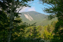
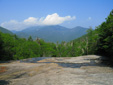
After about a fifteen-minute break, we carried on down the trail, shortly reaching an open meadow complete with our first view of Mt Marcy—spectacular, but an even better view awaits just ahead, this one featuring Little Marcy, treeline, and the broad summit of Mt Marcy. There is also an excellent vantage point that features a perfect view of Mount Haystack and Little Haystack. The view is beautiful but daunting, a reminder of the climb yet to come—thankfully, it is easier than it looks.
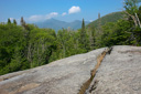
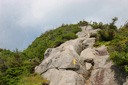
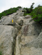
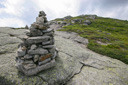
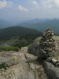
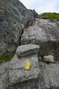
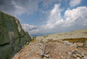
In another half-mile, we reached the Phelps Trail junction (11:44 am/6.7-mile mark)—turn right at this point and climb over a section of boulders and rocky slopes along the flanks of Little Marcy. We had now left the blue disks of the mixed conifer and deciduous forest behind to enter an arctic-alpine environment—the path to the top now marked by rock cairns and yellow blazes painted on the rock surfaces. As you traverse this fragile environment, keep to the principles of “Leave no Trace” and be mindful of your foot placements—stepping or sitting on the rare, fragile, and endangered plants will kill them—stick to the trail and stay on the bare rock.
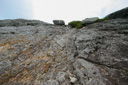
The final push to the top of New York is nothing short of exhilarating—the scramble up the steep rocky slope, combined with the incredible views, make this last section of the hike the highlight of the trip. Green and black lichens cover the rock beneath your feet and white flowering mountain sandwort sprouts from the crevices, adding a splash of color to the barren mountain environment above treeline. In addition, the mountain views seem to go on forever, especially if you have clear weather on your ascent.
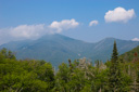
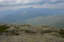
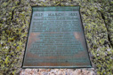
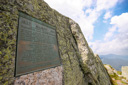
Rock cairns and yellow blazes slowly fade from view as you find yourself standing on the highest mountain in the state of New York, indeed, Mt Marcy is also the highest point in the Adirondack Range and one of only two peaks in the range that tower above the 5000 ft mark—Algonquin is the second. On a clear day, the views encompass the MacIntyre Range, the ridges north to Canada and the Green Mountains of Vermont—look for the distinct outline of Camels Hump. Continuing higher, we made our way towards the plaque on the summit and then up the final rock scramble to the ultimate highpoint—clouds were beginning to roll in and the views were quickly dissipating, but our enthusiasm was not dampened. My watch read 12:20 pm—time to enjoy the rewards of a five hour climb.On the summit, we explored the area and conversed with Dee—a knowledgeable naturalist and ADK steward entrusted to protect the fragile summit environment. She shared with us some interesting history of the summit, and educated us on the plant life and importance of protecting the arctic-alpine community.
Further exploration of the summit, revealed a USGS marker embedded in a rock just below the highest point—something that we are always keen to find on our mountain adventures. After spending nearly an hour on the summit, we decided it was time to begin our descent—just as soon as we started climbing down the mountain, the distant clap of thunder sent shudders down our spines. A reminder that the last place you want to be during a thunderstorm is above treeline on a wet rocky surface—a fact that put a spring in our step and sent us scrambling off the summit as quickly as possible.
As we descended from the summit of Marcy, the claps of thunder sounded off with increasing frequency—announcing the approach of the storm—we could only hope that the lightning bolts would keep their distance. The rain and cold wind soon joined the drama, making the climb down the steep rocky slope a rather treacherous endeavor. For the remainder of our hike, the thunder and rain would come and go, but thankfully, we never encountered any lightning strikes. The rain soaked trail did yield some interesting hiking techniques however, often slowing us down to a pace that allowed us to enjoy the song of several white-throated sparrows—identified by the mnemonic Old Sam Peabody, Peabody, Peabody—even a little red eft made an appearance on the trail. The saturated colors of the forest, thanks to the overcast skies, really brought out the beauty in the wood sorrel, Indian pipes, bluebead lily, ferns, and lush mosses that line the trail—nothing like beautiful flora to take your mind off puddle jumping.
The miles ticked off as we retraced our steps back towards the parking lot, until finally we were back at the trailhead register at 5:31 pm—don’t forget to sign out at both registers on your return journey. We had successfully climbed another amazing mountain, experiencing a variety of weather conditions along the way, and adding to our highpoint list the beautiful and challenging summit of Mount Marcy—may the odyssey continue!
 |
 |
 |
 |
 |
 |
 |
 |
 |
 |
 |
 |
 |
 |
 |
 |
 |
 |
 |
 |
 |
 |
 |
 |
|
|
|
|
 |
 |
 |
 |
 |
 |
 |
 |
 |
 |
 |
 |
 |
 |
 |
 |
 |
 |
 |
 |
 |
 |
 |
 |
 |
 |
 |
 |
 |
 |
 |
 |
 |
 |
 |
 |
 |
 |
 |
 |
 |
 |
 |
 |
 |
 |
 |
 |
 |
 |
 |
 |
 |
 |
 |
 |
 |
 |
 |
 |
 |
 |
 |
 |
 |
 |
 |
 |
 |
 |
 |
 |