
Mount Adams
Gifford Pinchot National Forest, Washington

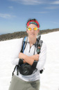
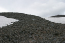
Climbing a mountain is a good way to test yourself, and Mount Adams was one test we weren’t prepared to pass. You remember that feeling of staying up all night studying for an exam, feeling totally prepared to ace every question, and then they lay the test in front of you and you feel like you memorized the wrong chapters…well that is how we felt about half way up Adams. It was as if we had totally misjudged every aspect of the climb. It wasn’t really apparent until we were near the top, especially as we trudged through the boulder field. With every stone that I managed to trip over this sinking sensation became stronger and this little voice in the back of my mind kept repeating…you aren’t going to reach the summit!
Don’t get me wrong, I have had my ass kicked by other mountains before this one, but Mt Adams was truly an eye opener. We had decided to give Adams a try when we found out wew would be visiting Washington in August, and who can pass up an opportunity to climb a mountain in the Cascades. Admittedly, not much preparation was done for the climb besides the normal reading of route info, checking out trip reports, calculating mileage and red tape etc, but we felt adequately prepared. I think what really led to our predicament was the lack of physical training and the fact that we were not able to acclimatize prior to our ascent. So hopefully you are wondering by now…Did they make it to the summit or not? Well, read on to find out.
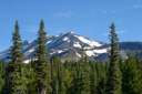
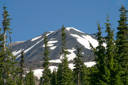
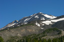
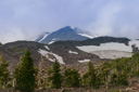
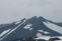
First, let’s learn a little background info on the mountain. Mt Adams, with its summit of 12,276 feet elevation, is the second highest peak in Washington State and the third highest peak in the Cascades Range. There are several climbing routes on the mountain, ranging from the "non-technical" South Climb, which is the route we opted for, to highly technical routes that require advance skill, experience, and special equipment. The only special equipment required on South Climb #183 is an ice axe and crampons; no roping skills or other technical climbing skills are needed. Even though the route is not technically challenging, it takes climbers at least 6 to 8 hours to ascend the nearly 6,700 vertical feet across snow and rock to reach the high altitude summit of Mt. Adams. Note that, in addition to the 6 to 8 hours of ascent time, you must allow for 4 to 6 hours to get back down off the mountain. This was another tidbit of critical information that my mind decided not to process during my early preparation for the route. It wasn’t until we picked up our Cascade Volcano Pass and I was rereading the info that it dawned on me…what the hell was going on? I was sure the entire hiking time was 6-8 hours! Crap. That was 4 to 6 hours I hadn’t factored in to our start time. This never happens, but there is a first time for everything, and for us time was everything.
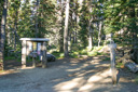
We had arrived in Seattle just a day earlier, managed to drive to Hood River and catch about 5 hours of sleep before we headed for the mountain the next morning. Not the best scenario for a dayhike up a massive pile of rocks, but nonetheless we were hopeful that luck and experience was on our side. By the time we drove to the Ranger station, picked up our pass, and bounced down the narrow, rutted Forest Road 8040500 it was 8:00am; still plenty of time to accomplish the dayhike, or so we hoped.
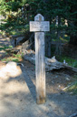
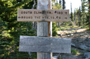
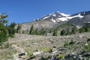
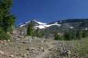
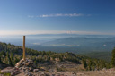
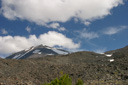
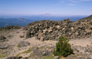
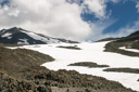
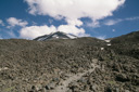
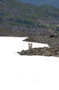
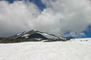
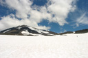
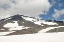
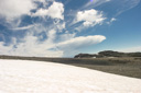
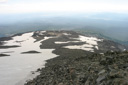
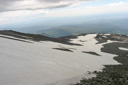
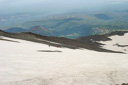
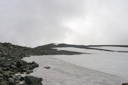
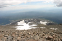
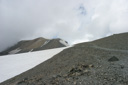
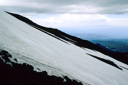
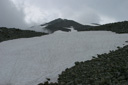
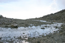
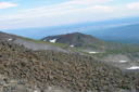
The trailhead leaves from the end of Forest Road 8040500 near Cold Springs Campground. The starting elevation is about 5,360 feet and is approximately 5.7 miles from the summit of Mt Adams. The trail is easily followed at first, as it is maintained, to about the 8,000 foot mark. This elevation marks the start of Crescent Ridge and the beginning of the unmaintained trail to Lunch Counter at about 9,000 feet. The Lunch Counter is a flat area on the mountain where it is traditional to stop and either camp if you are backpacking, or eat lunch if you are day hiking. From there the route gets even more sketchy as you hike over snow and boulder fields on your way towards Pikers Peak (the false summit) at 11,700 feet. From Pikers Peak the summit lies to the Northwest, approximately 600 feet higher, across a saddle.
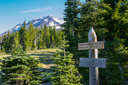
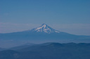
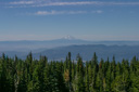
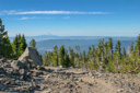
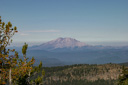
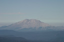
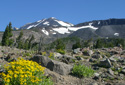
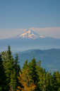
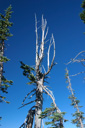
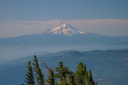
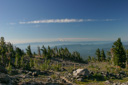
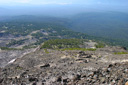
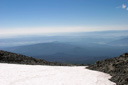
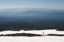
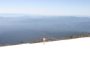
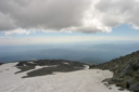
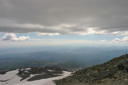
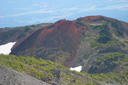
We set out on the trail under blue skies, armed with crampons and ice axes, with hopes of a summit and a fun glissade (our first) down the mountain. The first part of the trail, as mentioned earlier, is wide and easily navigated as it follows the remnants of an old road. The views are limited along this section, as you are still below treeline at this point in the hike. At about the 2 mile mark you will reach timberline and the intersection with Round-the-Mountain Trail #9 where you have a good view of Mt Adams in front of you and of Mt Hood to your back. Continue along South Climb #183 past summer wildflowers and gnarled trees and you will soon be rewarded with a spectacular view of Mount St Helens to the west. In just a few days we would be climbing St Helens, almost ten years to the day from our last climb to her summit, or at least that was the plan. Unfortunately, weather (that lovely rain cloud that plagued most our 2004 hikes followed us here too—at least we ended the drought for the Pacific Northwest) and other circumstances caused us to forfeit our permits. But we didn’t know that at the time and it was a thrill to see the volcano from the slopes of another mountain.
After a few wrong turns (the trail was hard to follow above Crescent Ridge) we found our way back to the route, and then we stopped for lunch. It was 11:20am, elevation 8,010 feet. We discussed the fact that we were moving rather slowly for us, and we both concurred that we were not feeling up to our normal level of fitness. We just hadn’t given ourselves enough time to rest from our flight and get used to the elevation, and the fatigue was slowly taking its toll on us. But lunch energized us and our confidence went up a few notches, but we were both kicking ourselves for slacking off of our training regimen during the summer. It was amazing what a difference it was making in our performance, and it was definitely a wake-up call!
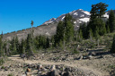
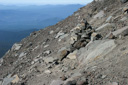
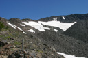
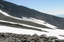
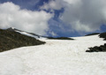
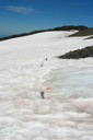
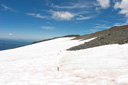
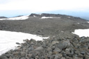
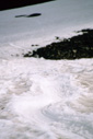
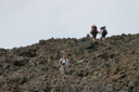
The going was really rough for both of us, but we managed to climb another 1,040 feet before we stopped for a break. We had skirted the edge of Crescent Glacier, made our way past the Lunch Counter, and were now at 9,050 feet. It was 12:30pm and we were ready to begin the steep climb up the snowfield to the false summit of Pikers Peak. The snow was a good consistency and crampons were not necessary for the climb, we would also occasionally hike along the boulders of the talus ridge just west of the snow field if we felt we needed a better foot hold. This part of the climb was excruciating! I don’t think I have ever used as much profanity on a hike as I did on this one. I swear the slope was nearly a 45 degree angle! On any other day I would have enjoyed the challenge, but on this day I just wanted to sit down and end the misery, but on I trekked.
We had set a cut-off time of 4:00pm, meaning that if we weren’t to the summit by 4:00pm we would turn around and head back down the mountain. This was done for several reasons, the main reason being that if we weren’t off the top of the mountain by sundown it was going to get very difficult to navigate the descent. Not only because it would be dark, but because the snowfield would turn into an icefield when the temperature dropped. We were no strangers to hiking in the dark, all we needed was our headlamp to follow the trail and we were good to go, but this hike was different. The difference came from the fact that there was no trail to follow; we knew we needed to be to at least Crescent Ridge by nightfall or we would never find our way. We had 3,226 feet to go and three and a half hours before our cut-off time, with a little bit of luck we figured we just might BS our way through this exam.
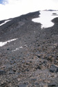
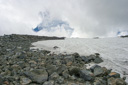
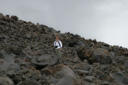
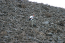
The trek up the boulder field continued to take its toll, as the rocks were beating the optimism right out of my psyche - with every misstep the boulders promised a twisted ankle. Normally I am very sure footed on rocks, but like everything else on this crazy day, that eluded me as well. I couldn’t seem to pick a line where the rock didn’t start into a death wobble, or where I didn’t stub my toe which in turn would throw me into a death wobble. It just wasn’t fun. I was ready for it to be over, but the summit was still looming. I could see we were making our way to the false summit, and our goal was slowly coming into reach - perhaps soon the suffering would all be worth it.
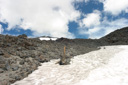
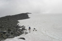
When I joined my fellow hikers on Pikers Peak, I was so relieved to know we were so close to the summit, but that closeness was only on paper. The summit of Mt Adams was only a few miles away and yet it was so far, it just didn’t seem possible to reach the top before our cut-off time. It was 3:34 pm and we were standing just below the summit at 11,040 feet. A mere 1,236 feet away from the top. We watched as other hikers made their way up the insane switchbacks just past the saddle, and we weighed our options. Should we continue on towards the summit and push our cut-off time? Or should we turn around and head back down the ridge? It was a dilemma we never expected to face.
Up to this point we had only had successful climbs, making the summit on every hike. Of course, we knew one day we would be forced to make this decision, but we never expected it would be on this hike. The turmoil this choice was creating was unbearable. We kept wavering between our choices, and we even set off towards the summit at one point before we stopped ourselves and decided to listen to reason rather than ego. It was obvious we just weren’t moving fast enough to push ourselves up to the summit at the speed we needed to be safe. When it finally sunk in that we really weren’t going to the stand on the top, we really weren’t going to see the lookout tower on the summit, we really weren’t going to see this hike through to the end, it was truly heart-breaking. To have come this far, and suffered through the climb, and not feel the glory of the summit just left us empty. The pull of a summit is a scary thing, and it gets many a hiker in trouble, but we all must know our limits.
After we wiped a few tears from our eyes, we turned our backs on the summit and focused our attention on getting back down safely. The clouds were starting to roll in at this point, so we consoled ourselves with the fact that the view from the top would not have been that great---just play along okay.
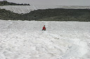
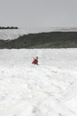
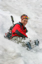
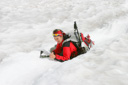
Our next decision would be whether or not we should glissade down the snow field or hike down the talus ridge. Well that was a no-brainer! I think we would all choose sliding down on our butts in the snow over that knee-jarring climb down the rocks anytime! We had never glissaded before, so it was a little intimidating at first. It looked really steep, but it also looked like wicked fun. All we needed to do was control our speed with our axe, so we geared up with our ice axes and hit the chute.
We managed to slide down the mountain without losing control - it was the most fun I have ever had on a mountain climb! It was like being a kid again!
The rest of the descent was pretty uneventful, except for getting off track once again near the Lunch Counter. It was really difficult to determine the proper route when there really weren’t any landmarks to help navigate. Thankfully we found our way, and the fact that we went off track even during the daylight only helped to solidify in our minds that we had made the right choice by turning back. We were back at our car at 7:03pm with our egos a little bruised, but not battered. Of course we have second, third, and fourth guessed our decision to turn around, playing out every timing scenario over and over, but in the end it was the right thing to do. Next time we will be in better shape and better rested. So get ready Mt Adams, the NBH Crew will be back someday, and perhaps then you will deem us worthy of your summit.
 |
 |
 |
 |
 |
 |
 |
 |
 |
 |
 |
 |
 |
 |
 |
 |
 |
 |
 |
 |
 |
 |
 |
 |
 |
 |
 |
 |
 |
 |
 |
 |
 |
 |
 |
 |
 |
 |
 |
 |
 |
 |
 |
 |
 |
 |
 |
 |
 |
 |
 |
 |
 |
 |
 |
 |
 |
 |
 |
 |
 |
 |
 |
 |
 |
 |
 |
 |
 |
 |
 |
 |
 |
 |
 |
 |