Mount Katahdin—Highpoint of Maine
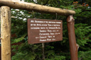
Baxter State Park, Maine

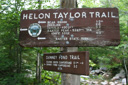
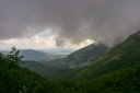
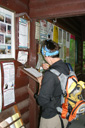
Early morning summer rain can evoke several different emotions, particularly when it is falling on the day you are hoping to climb to the summit of the highest point in Maine. We were reeling with anticipation, hoping that the day would clear up enough for us to reach the peak of Mt Katahdin. We arrived at the entry gate to Baxter State Park, home of Katahdin, at 5:30 am (you have to arrive early because once the parking lots are full the trails are closed for the day). The ranger asked our plans for the day, and upon our declaration to climb Katahdin, she informed us that today was a Class 2 day. This means that park officials do not recommend that you hike above tree line, but in any case, all trails are open. Our original plan was to hike to the summit via the Helon Taylor Trail and the infamous Knife Edge, but that darn summer rain was playing with our emotions, and causing us to reconsider our options.
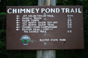
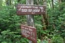
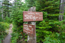
The morning was damp, cold, and windy. Would it still be possible to hike our chosen paths, or any path for that matter? We huddled in our car and waited as the sun began to rise and cast its gray light on the day. The parking lot at Roaring Brook was pretty much empty, a few hearty hikers were setting out on their treks, but most, it seemed, had abandoned their plans. We were still wavering. At once determined and skeptical, we weighed our alternatives. After much conjecture, we opted to head for the summit; all we had to do now was pick a new route (it was obvious the Knife Edge would be way too dangerous in the wind and rain). The ranger at the information station suggested that we take the Chimney Pond Trail to Chimney Pond, where we could reassess the weather and either push on or turn around. We agreed with that plan and set out to begin our journey.
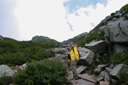
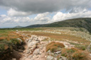
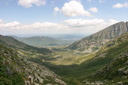
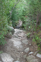
At 7:15 am, under gray skies and light rain, we started hiking the 3.3 mile trail to Chimney Pond. The trail was gradual in its ascent and only moderately strenuous. Portions of the trail are quite rocky, and require a bit of bouldering, but nothing too crazy. The first section parallels the cascade of Roaring Brook, and the scenery is reminiscent of The Great Smoky Mountains. The trail leaves the brook at about 0.5 miles and then begins to climb more steeply to its destination. We were making good headway, steadily tramping our way towards the pond, arriving at half-way rock at 8:15 am. The rain had stopped falling at this point, and we were hopeful the summit was in reach.
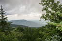
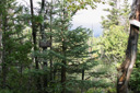
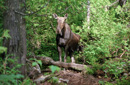
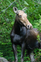
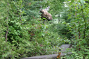
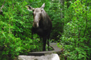
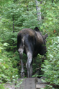
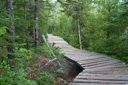
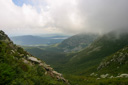
After a short side-trip from half-way rock (on the left) to a viewpoint (on the right) with nice views of the mountain range, we continued on up the trail. What was to happen next was an absolute highlight of the hike! Let me set this up for you a little. Okay, I was hiking along, mostly looking down at the ground due to the rocky composition of the trail; trying to make sure I placed my feet in the right places, when we came to a boardwalk. At this point, I raised my head to look forward for the first time in quite awhile, when I was greeted with two big brown eyes staring back at me. I was so startled to see someone, or rather something, looking back at me that I stumbled a few feet back - there, just seven feet away, standing smack in the center of the boardwalk, was a HUGE cow moose! I was so stunned that I almost forgot to take pictures! Once I came to my senses I snapped a few photos and waited to see what she would do. The moose, rather nonchalantly, looked us over and stood her ground, as she feasted on a few leaves from the trees. After several minutes we began to wonder just how long she was going to block the boardwalk, but then again, we couldn’t think of a better dilemma then a moose blockade! About ten minutes passed before she meandered off into the woods on the side of the boardwalk, we then attempted to proceed forward, only to have her get spooked and head again for the wooden planks. She would then, in a comical manner, poke her head out from the woods to assess the situation, and then she would retreat again. This went on for about twenty minutes…us giving her room, her retreating, us trying to proceed, her coming back, it was truly hilarious! Until, finally, she ran off to the watery comfort of Lower Basin Pond. All I can say is “Wow! That was cool as a moose”
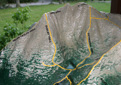
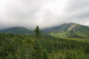
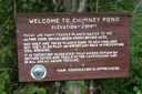
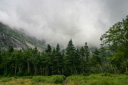
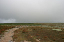
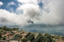
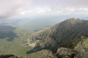
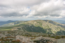
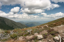
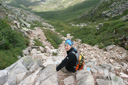
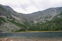
We were now highly energized and only 0.7 miles away from Chimney Pond. The rain was still falling on and off, but nothing too bothersome. We hiked into Chimney Pond Campground at 9:20 am, where we promptly added a few layers to ward off the chill from the gusty wind. At this point we were pretty determined to make it to the top, but we didn’t want summit fever to get the best of us, so we decided to take a break and eat some snackies and talk to other hikers. We met two really nice guys, local Mainers, who had been to the summit several times. They were of the opinion that, even though it was windy, the summit was safely achievable. That was just what we wanted to hear! In addition, no warnings or cautions were posted at the Ranger Station, and there was no ranger in sight to question, so we found a sheltered area out of the wind where we scarfed down our Oreo cookies and Payday candy bars for some quick energy. Our final trail to the summit would be the Saddle Trail, but before taking off we headed down to the shores of Chimney Pond (2,930 feet) to check out the view. And what a view it was! Chimney Pond is a beautiful alpine pond set in the vast glacial cirque known as the South Basin, it has towering peaks framing it on three sides and the water is crystal clear. A great place for a rest of tired legs, but our rest would not be long, as we were anxious to reach the summit.
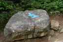
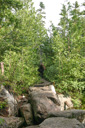
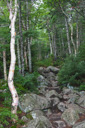
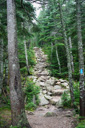
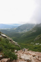
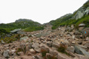
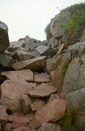
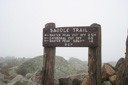
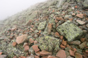
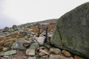
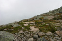
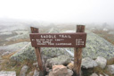
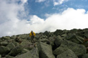
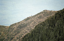
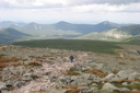
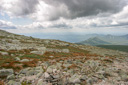
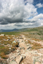
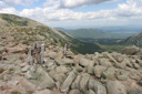
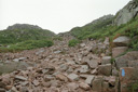
It was 9:42 am and we were heading up the Saddle Trail which would get us to Baxter Peak (Katahdin) in 2.2 more miles. The trail climbs through birch and spruce-fir woods, up rocky footing to more scrub like growth, towards an awesome natural phenomenon called the Saddle Slide. The slide came down in 1893 and now offers the hiker some great scrambling. Making your way up the pink granite boulders of the landslide is no easy task. You must have good physical conditioning to pull yourself up some of the steeper sections. The slide is only 0.2 miles long but it can really sap your energy. You must be cautious in this area of your own actions, and of the actions of other hikers. Anyone can easily dislodge a rock and send it hurling towards an unaware hiker, so keep your wits about you and pay attention to your footing, and of any hikers above you on the slide. Blue blazes are your only guide while climbing this steep section of trail, so be sure to keep an eye on the next blaze while choosing your route.
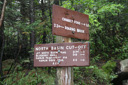
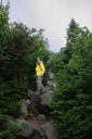
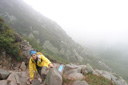
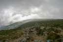
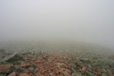
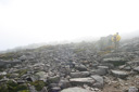
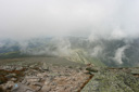
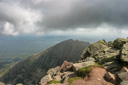
Once we were at the top of the slide we couldn’t believe the wind! It was really gusting, at around 50 mph in my estimation. It literally knocked both of us off our feet on several occasions. Yeah, good decision to stay off the Knife Edge! I couldn’t imagine being on that trail in this wind! As we made our way further up the mountain the fog settled in over our trail. Following the blue blazes through the boulder field was getting a little difficult in the declining visibility, but not impossible. We stuck it out, and by the time we reached the Baxter Peak cut-off trail the sky was starting to open up. Little patches of blue sky were peaking through the clouds and the wind was dying down a little. Just 0.5 more miles and we would be at the summit, we hoped the weather would continue its turn for the better.
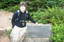
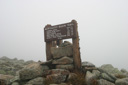
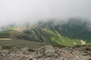
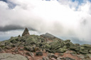
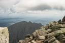
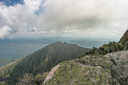
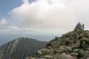
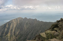
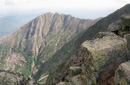
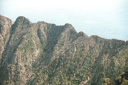
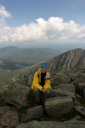
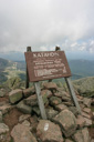
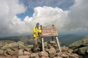
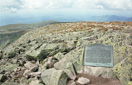
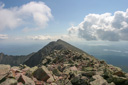
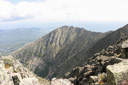
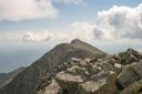
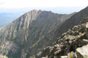
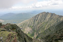
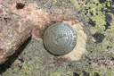
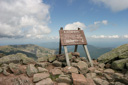
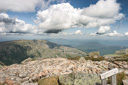
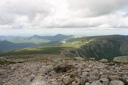
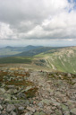
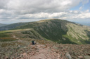
The summit sign was now in sight and the weather was still getting better, and even though the wind was still a little gusty, it was much calmer than before. At 11:40 am we took our final step on the Saddle Trail and placed our feet on Mt Katahdin, the highest point in Maine, the Northern terminus of the Appalachian Trail, and the sixth highest mountain in New England! We had hiked 5.5 miles and gained 3,800 feet in 4 hours and 25 minutes, and as a reward the fog was moving off the summit and the views were opening up. The Knife Edge jutted out of the scenery like some kind of spiny ridge on the back of a dragon. Believe it or not, we could actually see some brave, or just crazy, hikers out on the serrated trail. We explored the summit for about an hour, and actually toyed with the thought of descending via the Knife Edge, but every time we would lean towards a yes vote, the wind would come along and just about knock us over again. We took the hint and decided to return the way we came.
The hardest part of the descent was climbing down the Saddle Slide, but the rest of the trail was hiked rather easily. We left the summit at 12:30 pm and were back at Chimney Pond at 2:10 pm, and to our car at 3:48 pm. We had hiked a total of 11.0 miles in 8 hours and 30 minutes, including an hour at the summit, and we still had the afternoon to explore Baxter State Park. Katahdin is an awesome mountain and perhaps one day we will return and conquer the Knife Edge, but for now we are just happy to have stood on the top of Maine.
 |
 |
 |
 |
 |
 |
 |
 |
 |
 |
 |
 |
 |
 |
 |
 |
 |
 |
 |
 |
 |
 |
 |
 |
|
 |
|
 |
 |
 |
 |
 |
 |
 |
 |
 |
 |
 |
 |
 |
 |
 |
 |
 |
 |
 |
 |
 |
 |
 |
 |
 |
 |
 |
 |
 |
 |
 |
 |
 |
 |
 |
 |
 |
 |
 |
 |
 |
 |
 |
 |
 |
 |
 |
 |
 |
 |
 |
 |
 |
 |
 |
 |
 |
 |
 |
 |
 |
 |
 |
 |
 |
 |
 |
 |
 |
 |
 |
 |
 |