
Hugh Norris Trail
Saguaro National Park, Arizona
The Hugh Norris Trail, located in the Western district of Saguaro National Park, leads the hiker past towering saguaro cacti, huge granite boulders, and spectacular ridgeline views to the top of Wasson Peak—the highest peak in the Tucson Mountains. The trail, rated difficult, is a total of 9.8 miles roundtrip—awarding it the honor of the longest trail in the Tucson Mountain district. Despite being longer than other routes, the climb is gradual, the views from the ridges are incredible, and the summit of Wasson Peak offers an unforgettable 360-degree view of the Tucson valley.
We learned of this trail at the Red Hills Visitor Center, on an impromptu visit, and decided to check it out—the date was November 12, 1999—a beautiful day in Arizona, with an unseasonably warm temperature of 90° Fahrenheit. We left from the trailhead later in the afternoon, some time around 1:00 PM, determined to reach the summit.
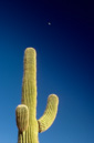
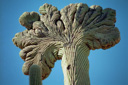
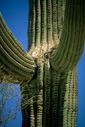
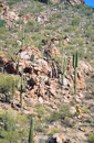
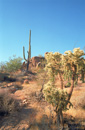
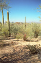
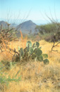
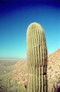
A sign at the trailhead broke down the mileage and gave the starting elevation as 2600 feet—the trail to the summit of Wasson Peak is 4.9 miles one way, with an elevation gain of 2,347 feet. The trail begins by climbing up a small canyon studded with amazing specimens of saguaro, and it provides early views across the broad basin of Avra Valley to the Waterman, Roskruge, and Silver Bell Mountain ranges, as well as the loftier Santa Rosa Mountains beyond. After about a quarter of a mile, the trail crosses a sandy drainage, climbs out, and then heads up the canyon directly between two ridges. As you gain in elevation, look back at the saguaro forest—there is no other place like this in the world—thousands of giant saguaros blanket the bajada, a Spanish term for the transition zone between the mountain and the valley. Beyond the saguaros, farmland stretches out as far as the eye can see.
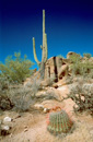
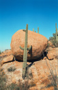
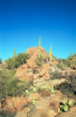
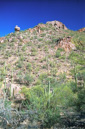
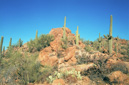
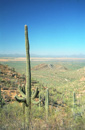
Once on the top of the ridge, the trail levels out, offering a respite from the initial climb, but soon you will gradually switchback your way towards the top of a small saddle. From this point, you can enjoy views of a red rhyolite reef topped by Panther Peak to the west, and Safford Peak in the center. The trail then drops into the saddle, where numerous granite boulders, framed by tall saguaros, make for the perfect lunch spot or photo opportunity. From the saddle, the trail then climbs steadily up the ridge towards Amole Peak—slowly leaving the saguaros behind with increasing altitude. As the ascent turns into a ridgeline trail, the views of the Catalinas, Picacho Peak, and the Rincon Mountains spread out before you. There is also an old mine shaft off the side of the trail, but resist the urge to explore as many lives have been lost in this manner—a sign just off the side of the trail warns of the danger involved with mine exploration. From this point on, the trail becomes rather steep as it makes its way towards Wasson Peak, via several switchbacks.
Once you reach the top of the switchbacks the views really open up, and it seems like you can see forever. Next, you come to a sign marking the intersection with the Sendero Esperanza Trail, from this point it is 2.2 miles to the highest point in the Tucson Mountains along a gradual climb up the northwestern side of the ridge. After half a mile the trail crosses a short saddle, from which the hiker can see both sides of the mountain—look ahead to the peaks, it is difficult to determine which one is actually Wasson, and unfortunately, it is not the one you want it to be, instead, it is the peak farthest away and to the left. After the saddle, the trail crosses back to the western side of the ridge. At a small sign marking the 4,000-foot elevation level, the trail traverses another short saddle, following the east side of the ridge along a smooth, sandy trail.
Most of the last half-mile of the trail is a series of steep switchbacks. At the top of the switchbacks is a signed trail intersection—the King Canyon Trail. The Hugh Norris Trail continues an easy 0.3 miles to the summit.
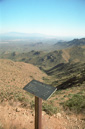
On the summit, you reward is an unobstructed view of the Tucson basin, including the huge saguaro that dot the landscape with prickly prowess. The Santa Catalinas hover above the horizon on the far side of the basin, and the volcanic peaks of the Tucson Mountains rise above the Red Hills to the south. You have now climbed nearly 5 miles through a scenic desert; gaining nearly half a mile in elevation—after a climb like that, don't forget to sign the register at the top in order to memorialize your summit success.
We took our time on the summit, enjoying the views, reading the comments in the register, and resting from the climb, and then as the sun started its downward path we decided to do the same. We made our way back to the car, and I swear the trail seemed to take longer going down then coming up, but we finally arrived back at our car at about 6:00pm, and promptly broke open the cooler in order to celebrate our successful summit with a Pepsi!
 |
 |
 |
 |
 |
 |
 |
 |
 |
 |
 |
 |
 |
 |
 |
 |