El Yunque Peak & Mt. Britton
El Yunque National Forest, Puerto Rico

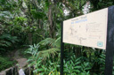
The Caribbean National Forest, or El Yunque, was set aside as a reserve by the Spanish in 1876 making it one of the oldest protected forests in the northern hemisphere. The forest became part of the USDA system in 1903, and it remains the only tropical rain forest in the U.S. National Forest System to this day. The forest reserve contains more than 23 miles of well-maintained trails, where plenty of rugged terrain and tropical weather combine to provide something for every hiker. We wanted to experience as many trails as possible on our visit, but we held one hike above all the others—the trail to the summit of El Yunque Peak (3,496 feet above sea level).
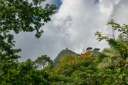
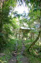
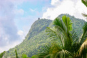
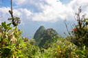
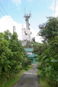
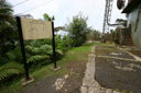
We arrived at the Palo Colorado Visitor Center early in the morning, ready to begin our quest for the summit of El Yunque, a mere 2.6 miles away. We piled out of the car and peered up through the lush tropical canopy, there, through a break in the foliage, we could see the tower of Mt Britton soaring high above the rainforest, framed beautifully by the bright orange blooms of the tulip trees. The view was inspiring, as we would also be bagging the peak of Mt Britton on this hike.
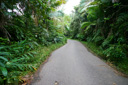
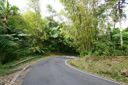
El Yunque Trail is an out and back venture, so if you want to see new scenery on your return journey, the best thing to do is to combine several trails and a portion of Forest Service Road 10 to form a loop trail. Our plan was to make use of the following trails to form a loop roughly 5 miles in length—we set out on the Bańo Grande Trail, joined the El Yunque Trail and followed it to the summit, hiked the side trail to El Yunque Rock, walked down FS 10 and then hiked to the observation tower on Mt Britton’s summit before returning to FS 10 for a short jaunt until we caught the Mt Britton Trail, which then lead us to State Route 9938 and eventually to Highway 191 and back to our car.
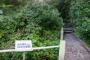
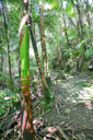
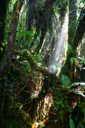
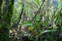
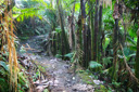
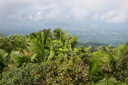
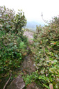
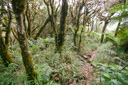
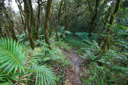
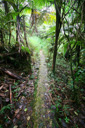
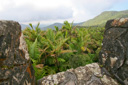
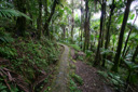
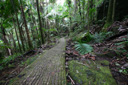
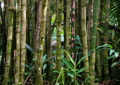
The moment you step onto the El Yunque Trail, you are immersed in a different world—a world of lush rainforest perched on the slopes of the rugged Luquillo Mountain Range. El Yunque actually consists of four distinct forest zones: tabonuco or rainforest, palo colorado forest, sierra palm forest, and dwarf or cloud forest. You will pass through three of these zones while climbing Pico El Yunque, everything except the tabonuco forest is represented, as this part of the reserve is found only below 2,000 feet. The El Yunque Trailhead begins at an elevation of 2,047 feet and climbs to the summit at 3,496 feet for an elevation gain of 1,449 feet in 2.6 miles. The trail begins at the concrete steps across from the visitor center, leading to the Bańo Grande pool. At the top of the steps the trail turns right and proceeds along the Caimitillo trail for approximately 150 feet to the El Yunque trail junction—marked by a Forest Service sign. Continuing on, the hiker passes through the lush canopy of the Palo Colorado forest into the higher elevations of the Mountain Palm (Palma Sierra in Spanish) forest, eventually reaching the mysterious ever clouded Dwarf Forest at the trail’s end.
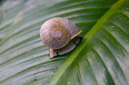
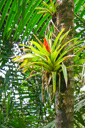
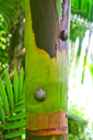
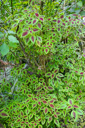
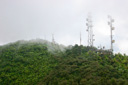
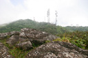
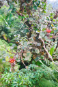
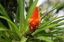
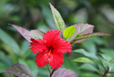
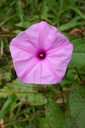
We set out for the summit at 10:00am, enjoying the fantastical sensory experience provided by the sights, sounds, and scents of the forest. Coquis, a highly vocal but tiny tree frog, could be heard producing the famous “co-kee” sound, snails quietly ate there way through the forest, and doves were cooing from there lofty perches. Red bromeliad blooms and orchids decorated the trees, and pink impatiens lined the trail, and an occasional butterfly flittered across our path. Above all, the El Yunque Trail is defined by the rainforest it infiltrates. There, stoked on the nearly 300 inches of annual rainfall, ferns reach outrageous heights, and moss drapes everything that doesn’t move, and all the while the ground remains moist and muddy—shaded by the impressively tall trees. In fact, everything is impossibly tall and green, creating a head-craning atmosphere that makes it easy to miss a trail junction if you are not careful. Of course, we did just that and took a small detour along the Caimitillo Trail before noticing our mistake, a short back-track put us back on the right path and on our way to the Los Picachos Trail. We reached the Picachos Trail junction at 11:33am, but we decided to save the climb up the rocks for our return journey—an oversight on our part, as we ended up not passing this way on our return. After hiking another 15 minutes, we came to an opening in the trees which gave us our first view of the radio towers that reach skyward from the summit of El Yunque.
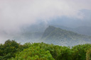
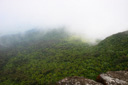
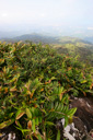
On the trail, it became obvious that we were entering a new forest zone—the realm of the cloud forest. A land of twisted and stunted vegetation, hence its other name, dwarf forest, where the weather is harsh and bands of fog are often present. Pick and I were impressed with the epiphytes, or air-growing plants, that love these wet foggy conditions, which is why they were growing almost everywhere we looked.
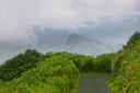
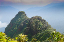
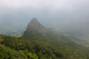
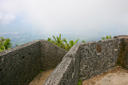
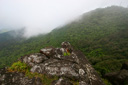
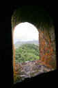
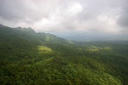
Not long after our first view of El Yunque’s peak, we were making our way up the service road that lead directly to the summit. We noted the time as 12 noon, and then sat down to enjoy a snack and some beverages. Despite the fact that we shared the summit with a communications tower, we still felt as if we were in the middle of a vast expanse of wilderness. Indeed, we had a panoramic view of the entire forest from the top of the observation tower, we could also see El Yunque Rock—our next conquest—looming in the distant fog.
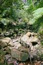
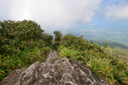
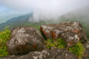
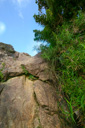
From El Yunque Peak you can reach El Yunque Rock by taking a short walk back down Forest Road 10 (closed to traffic) where you will see the trailhead on your right. The trail to the top of the rock climbs 0.1 mile through a beautiful section of the cloud forest, where the trees are particularly twisted and heavily covered in epiphytes and mosses. The trail is relatively level until the last section, which requires a short scramble up a jumble of boulders. When we were there the view from the top was obscured by clouds, but on a clear day you can see the Atlantic and possibly San Juan in the distance.
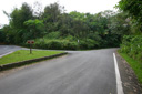
Back on Forest Road 10, we began hiking towards Mt Britton—the road is easy to follow, mostly downhill, and offers a surprising amount of wildlife and flora viewing. As we walked along the road we were lucky enough to see a Puerto Rican Tody and a Lizard Cuckoo, both of which, unfortunately, eluded my camera—that will teach me to hike with my telephoto lens in my backpack. Eventually, I was able to get the lens out, but the birds had disappeared. After stalking them for awhile we gave up the hunt and continued on down the road, reaching Mt Britton about 30 minutes later.
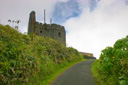
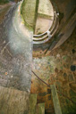
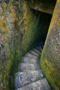
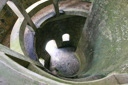
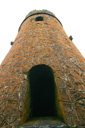
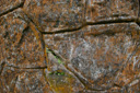
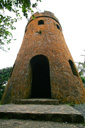
The Mt. Britton observation tower resembles a castle turret, complete with a spiral staircase leading to the top where you can get a good view of the coast and the rainforest. The hike to the tower from Forest Road 10 is practically over before begins, so don’t be concerned about over exertion on this summit attempt—unless of course you are hiking up the Mt Britton Trail. We liked the fact that we would be hiking down this steep trail, rather than up. Once at the tower, we climbed to the top and enjoyed the view. From the base of the tower we were fascinated by the orange lichens that grew on one side, giving it a unique appearance. We spent about 15 minutes exploring the area, and then set off for the Mt Britton Trail, about 500 feet down the road.
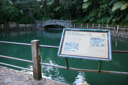
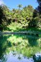
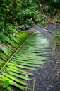
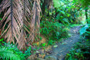
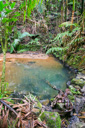
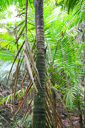
The Mt Britton Trail, a 0.8 mile one way hike, leads the hiker through the palm forest, crossing several streams along the way. The trail, as is the case with just about all the trails at El Yunque, is paved and can often be wet and slippery—so mind your step. The Sierra Palm Forest is unique within this diversified environment, in that it is a kind of monoculture all to itself. Gone are the hundreds of different species of flora, replaced by the dominate sierra palm with its white flower spikes and prop roots. Adding to the beauty of this part of the forest is the stream that follows parts of the trail. In particular, near the trail’s entrance there is a small man-made pool which is rather eye-catching. The downhill trek took us about 20 minutes, placing us at route 9938 at around 2:00 pm and back at our car at the Palo Colorado Visitor Center at 2:10 pm.
Many people who visit El Yunque National Forest will scarcely get out of their car, but if you want to experience the true nature of the rainforest then consider this highly evocative loop—you will be glad you left that metal box on four wheels behind!
 |
 |
 |
 |
 |
 |
 |
 |
 |
 |
 |
 |
 |
 |
 |
 |
 |
 |
 |
 |
 |
 |
 |
 |
|
 |
|
 |
 |
 |
 |
 |
 |
 |
 |
 |
 |
 |
 |
 |
 |
 |
 |
 |
 |
 |
 |
 |
 |
 |
 |
 |
 |
 |
 |
 |
 |
 |
 |
 |
 |
 |
 |
 |
 |
 |
 |
 |
 |
 |
 |
 |