
Auxier Ridge and Double Arch Loop Trail
Red River Gorge Geological Area, Kentucky

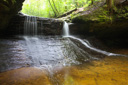
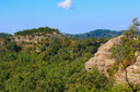
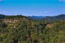
The Red River Gorge Geological Area, located about sixty miles southeast of Lexington in the heart of Kentucky, protects forested hills, sandstone bluffs, and over 160 natural stone arches—in the United States, only Utah’s Arches National Park has more. Amid this pristine geological area, the Red River flows through a deep gorge in the northern portion of the Daniel Boone National Forest, creating a spectacular playground for nature lovers—complete with miles of hiking trails, rock climbing, waterfalls, and amazing scenery.
Two scenic drives, the Red River Gorge Scenic Byway and the Bert T. Combs Mountain Parkway, both provide access to the numerous attractions found within the gorge. Most notably, we enjoyed the Gladie Cultural-Environmental Learning Center and historic Gladie Cabin, Angel Windows, Rock Bridge and Creation Falls, the Nada Tunnel, Princess Arch, SkyLift and Natural Bridge State Resort Park, and the spectacular hiking loop encompassed by the Auxier Ridge/Courthouse Rock/ Auxier Branch/Double Arch Trails.
 |
 |
 |
 |
 |
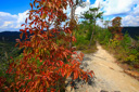
There are dozens of trails along the ridge tops of the gorge and still more that follow the river through the bottom of the gorge—some we were able to hike and others remain on our list for a future visit. Of the many trails that we hiked while visiting the gorge, we especially enjoyed the Auxier Ridge Loop—a 6.1 mile combination of trails leading to panoramic vistas and fantastic rock formations.
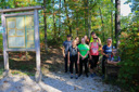
To find the trailhead, take exit 33 off the Bert T. Combs Mountain Parkway, go north for 0.1 mile on Kentucky Highway 11 and then turn right onto KY 15—head east towards Campton. After 3.5 miles, turn left onto the gravel Tunnel Ridge Road, which goes over and not through Nada Tunnel, and then continue driving for another 3 miles—pass the Gray’s Arch picnic area and arrive at the Auxier Ridge Trailhead by turning right into the parking area just before the gate across the road.
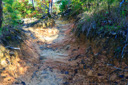
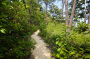
From the parking area, we set out on Auxier Ridge Trail #204 (blazed with white diamonds), following the path as it descended gently through a rhododendron thicket—known locally as “rhodie hells”—to a ridge that you follow with little elevation change to a junction with the Courthouse Rock Trail #202 at mile 0.9. For an easier and more scenic approach to Courthouse Rock, bypass this trail despite its name and continue hiking north on the Auxier Ridge Trail—both trails lead to the rock formation known as Courthouse Rock.
After passing the Courthouse Rock Trail junction, watch for a fork in the trail—turn right at the bend, rather than continuing straight, to stay on the Auxier Ridge Trail.
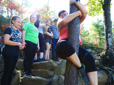
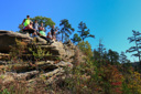
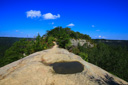
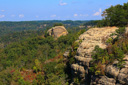
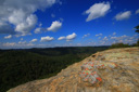
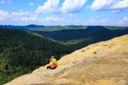
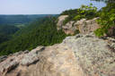
After a brief climb up to the ridge, the trail levels out and the views open up—the high ridge offers amazing views of Raven’s Rock (the tall flat-topped white cliff to the east), Double Arch to the west, and Courthouse Rock to the north. Several short paths lead out to the edge of the ridge for even better views of Double Arch and the Red River Valley—at this point, we explored the ridge and stopped for a rest and group photos. Continuing on, the ridge narrows with drop-offs on either side—although the ridge is not knife-edge, it is still possible to fall if you are not careful, as vegetation on both sides of the bare rock mask the steep bluffs.
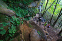
Leaving the ridge behind, our crew made their way over a small rock outcropping before reaching a long metal staircase that aids in the descent from the ridge—a wooden staircase follows the metal staircase and both sets of steps are steep and long. When we reached the bottom of the staircase, we could see Courthouse Rock and the other end of the Courthouse Rock Trail—at first, we were confused as to which route to take, but a brief discussion put us back on track.
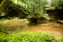
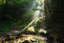
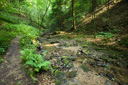
A quick jaunt down the Courthouse Rock Trail brought us to Auxier Branch Trail #203 and then on to Double Arch. The trail junction, more like a fork in the trail, found 0.3-mile from Courthouse Rock presents a choice to the hiker—take a left and return to the car via the Courthouse Rock Trail or take a right on the Auxier Branch Trail. In June 2008 we opted to hike to Double Arch—found off the Auxier Branch Trail. Taking a right at the fork, we descended into a small hollow complete with lush vegetation, sunbeams, and the perfectly placed boulder strewn waters of Auxier Branch.
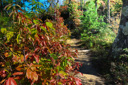
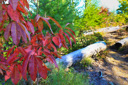
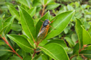
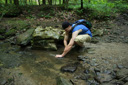
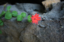
As we followed the creek upstream, our group—now scattered at varying intervals throughout the length of the trail—found many great vantage points for observing the riparian flora. The sun was shining through the forested valley, its low position in the sky creating beams of light that illuminated the flowing water and wildflowers along the edge of the stream—lush ferns and basil bee balm brought added beauty to the landscape.
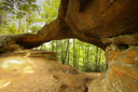
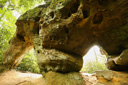
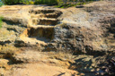
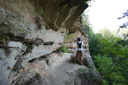
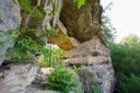
Upon reaching mile 3.1 of the loop, the Auxier Branch Trail dead-ends into the Double Arch Trail #201—a left would bypass the arch and a right leads to the phenomenal rock formation. Double Arch, spanning nearly 20 feet across, sits high on the ridge above Auxier Branch—the name double refers to fact that the arch is split into two portions, a thin upper arch and major lower arch.
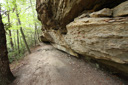
From the junction, the hike back to Double Arch is 0.8-mile one-way along a level trail that follows the base of the cliff before rounding a corner and climbing to the base of the arch—a series of steps aid in the climb. We arrived at Double Arch in the late afternoon and the sunshine was illuminating the sandstone, causing an almost ethereal glow—perfect timing. The view through the arch, across the valley, reveals the ridge that we had just traversed and of the valley far below—watch your step, the drop-off is steep. A quick bit of exploration, and a call from Pathfinder, led me to a trail off to the right of the arch that led to the top of the span—even better views can be had from this bird’s eye vantage point.
We retraced our steps back to the Auxier Branch Trail junction and then followed the Double Arch Trail south back towards the parking area—one last climb up another wooden staircase and a short hike down a gravel road and we were back at our car for a 6.1 mile roundtrip hike. One by one, our crew emerged from the trail, hot, sweaty, and ready for a cold beverage from the cooler—the Red River Gorge had given us yet another incredible way to enjoy our unspoiled national forests.
Auxier Ridge Photo Gallery October 2018(Total of 30 images)
 |
 |
 |
 |
 |
 |
 |
 |
 |
 |
 |
 |
 |
 |
 |
Auxier Ridge Photo Gallery June 2008
 |
 |
 |
 |
 |
 |
 |
 |
 |
 |